We focus on extracting new value from previously acquired orthogonal WAZ surveys in the Mississippi Canyon area where some of the largest and still active deep water discoveries reside. Some analyses estimate that many large subsalt/presalt fields can still be discovered. In this study, the subsalt images which are critical to exploration are enhanced by applying new processing methodologies. The key technologies that have contributed to improved images are:
- Common Offset RTM (COR) gathers for dirty salt and subsalt velocity tomography update
- Dual-Directional Image Stack (DDIS) with target image-based sum weighting to improve poorly illuminated subsalt areas.
Introduction
The study data for this paper is a subset of two orthogonal WAZ surveys in the Gulf of Mexico acquired in 2009 and 2012. Because this type of acquisition is expensive, and the area is still active to production, we apply new processing technology to help exploration and production teams extract more information from existing datasets without acquiring expensive new seismic surveys. In this area it is critical to better define salt geometry and improve poorly imaged subsalt structures.
The existing models are derived using Tilted Transverse Isotropy (TTI) model building and imaging which requires five parameters: VP, dip, azimuth and the Thomsen (1986) parameters ε and δ (Cogan et. al, 2011). VP was converted from a legacy Vertical Transverse Isotropy (VTI) velocity model and was updated with at least 6 passes of multi-azimuth tomographic inversion using Kirchhoff PSDM gathers through previous processing efforts; dip and azimuth were derived from dip scan of PSDM stacks; and anisotropic parameters ε and δ were generated through checkshot calibration. The salt model was built assuming a constant velocity value of 4500 m/s. The subsalt model was updated via tomography using Kirchhoff PSDM gathers and RTM delayed-imaging time (DIT) scans (Wang et al., 2008, 2009). Though the DIT method handles multi-pathing and illumination issues typically found in subsalt regions, the method tends to generate low resolution velocity updates.
In this paper, we take advantage of common offset RTM (COR) gathers to update via tomography, the velocities within salt as well as below salt. In this area of the Gulf of Mexico it is not uncommon for salt bodies to contain intrasalt sutures and sediment inclusions. The presence of these intrasalt reflectors leads to nonuniform salt velocity. After the salt velocity is updated, the salt geometry, especially the base of the salt, is adjusted. Next, another pass of COR tomography is performed to update complex subsalt areas where the quality of Kirchhoff PSDM gathers is often degraded because of poor ray illumination. Finally, the deep autochthonous salt is reinterpreted.
We also apply our geological knowledge to compose a target image used to weight partial RTM images. These images are formed by binning shot image traces based on the vector from source to image point.
Dirty Salt
For accurate imaging of subsalt targets, figuring out the most likely salt geometry through iterative processes and various scenario tests becomes one of the most critical steps in the velocity model building process. In addition to this complexity, moderate to strong velocity contrasts inside the salt such as intrasalt sediment inclusions of various sizes and sediment-salt mixtures, i.e. dirty salt, pose additional challenges. Some RTM-based methods are used to resolve these challenges. For example, the focusing-based method, DIT (Delaughter et al., 2014), is considered to be a cost-effective method to improve the base of salt definition and subsalt events, but it only addresses large scale average velocity changes. RTM angle gathers are used to update intrasalt velocity anomalies (Ji et al., 2011), but it might not be suitable for complex top salt cases due to the nature of limited angle information in some cases. A new approach using COR gathers is utilized to improve subsalt imaging quality (Rodriguez et al., 2016) which handles a broad range of anomalies with better precision when compared to Kirchhoff or RTM angle gathers for subsalt imaging.
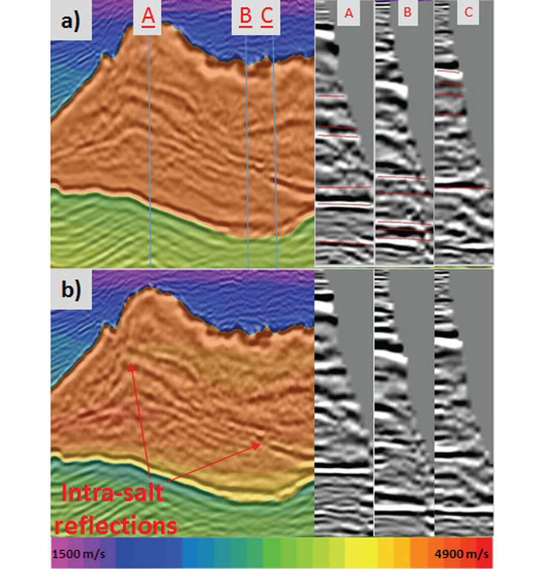
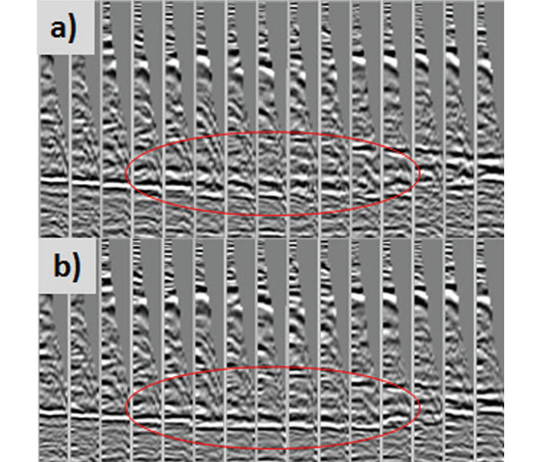
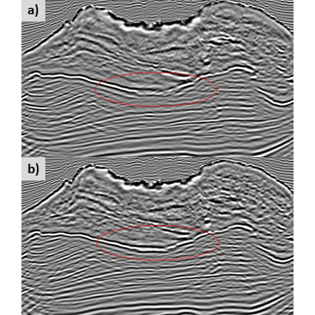
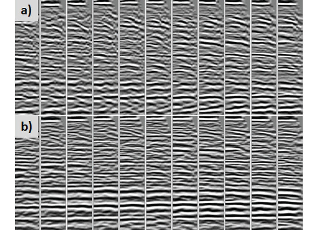
We update the velocity inside the salt through image-guided (IG) tomography (Hillburn et al., 2014) while using COR gathers to compute residual curvature. Figure 1 shows salt models with a uniform 4500 m/s velocity and a variable velocity after image-guided tomographic update. Selected gathers at three different locations overlain with residual curvatures in depth demonstrate the feasibility of picking proper events inside the salt. Figure 2 shows gathers across the salt body. In addition to top and bottom of salt events, many events (intrasalt sediment, multiples, converted waves) are clearly noticeable. Unnecessary events (multiples and converted waves) show extremely large moveout and are neglected when estimating the residual curvature. After a velocity update, many events, specifically the base of salt, show much better focusing and flatter gathers. Figure 3 shows significantly improved focusing in RTM stacks before and after a dirty salt velocity update which also resulted in a better well tie in the other well location.
Subsalt tomography via COR
Updating the subsalt velocity via traditional tomography using PSDM Kirchhoff offset gathers has always been challenging in the Gulf of Mexico due to the poor illumination below the complex salt bodies which are commonly observed. Various attempts have been made to address this issue, such as using reverse time migration (RTM) based delayed imaging time (DIT) scans to update the subsalt velocities (Wang et al., 2008, 2009). Recently, Rodriguez et al., 2016, proposed generating common offset RTM gathers (COR gathers) as an efficient method to provide high-fidelity subsalt gathers with improved signal-to-noise ratios to update subsalt velocities with existing tomographic algorithms and thus derive reliable subsalt velocities.
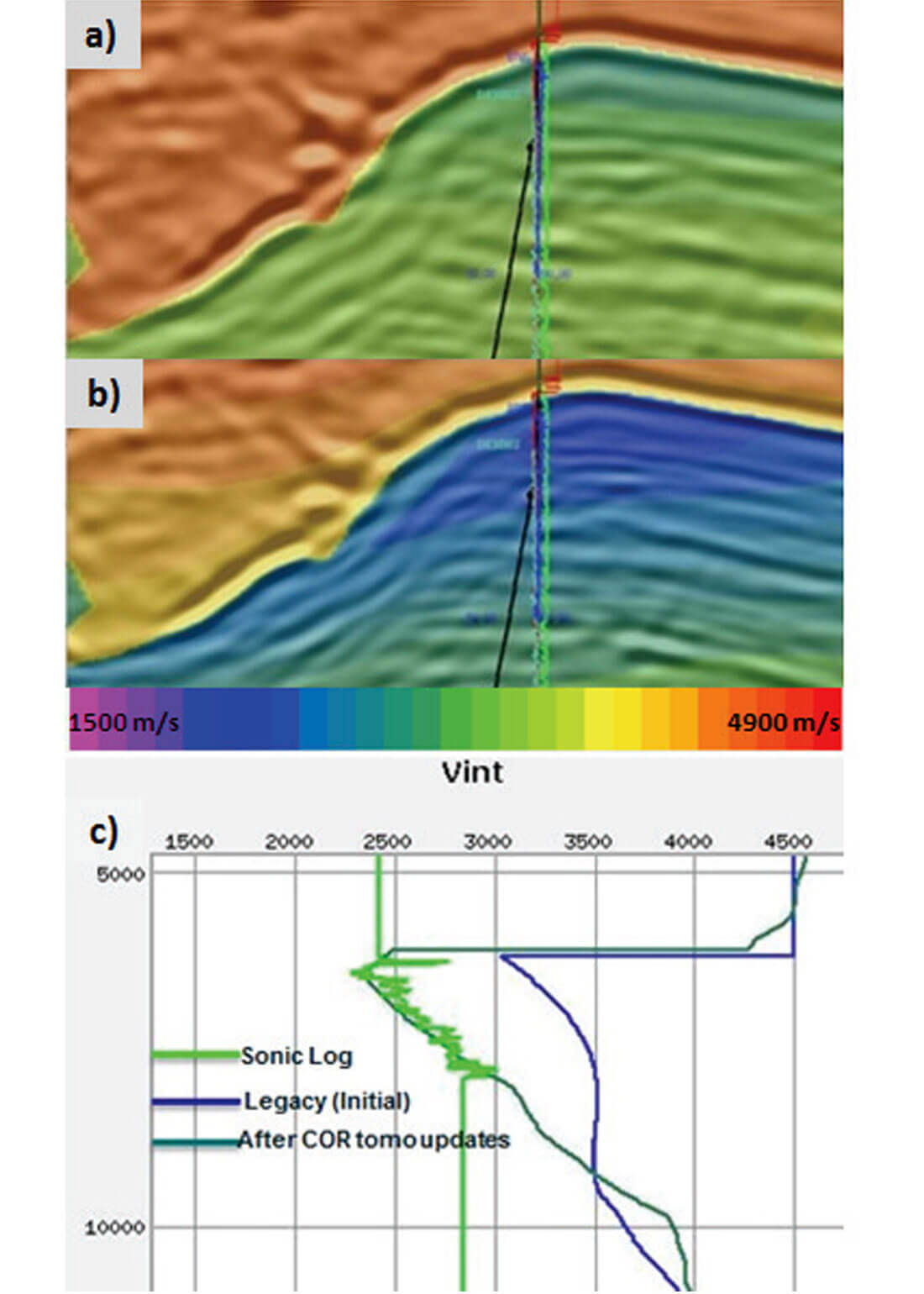
In this study, only two passes of subsalt tomography via common offset RTM (COR) gathers are performed to update the velocity in the subsalt areas. Noticeable improvements are achieved in the updated subsalt velocity and thus the imaged subsalt stacks and COR gathers. Figure 4 shows a comparison of seismic subsalt velocities and the sonic log. Slower velocities underneath the salt are observed on the sonic log. The subsalt velocity derived from subsalt tomography via COR correlates to the sonic velocities significantly better than previously derived subsalt models. Figure 5 shows many disconnected deep gathers, due to extremely slow velocity anomalies right below salt bodies. After subsalt tomography via COR, the subsalt COR gathers clearly show improved flatness in addition to more continuous and well focused deep gathers.
Dual-Directional Image Stacks (DIS)
To improve the signal-to-noise ratio below poorly illuminated subsalt areas, we utilize a technique that involves forming multiple partial-image stacks and generating a nonequal weighted sum according to the methodology described by Whiteside et al. (2012). This methodology is based not only on the idea of separately weighting shot images based on their source to image point vector offset, but also on taking into account the binning dimension of shooting azimuth. We utilize a structurally enhanced image based on interpreted horizons and measure correlations between the smoothed stack and directional image stacks. The partial images are weighted based on correlation coefficients before stacking. We apply the technique to each of the orthogonal WAZ surveys separately, and then sum the enhanced image of each survey based on semblance coherency weights. Figure 6 shows a comparison between regular RTM stack and DDIS RTM stack. The DDIS RTM stack reduces conflicting events parallel to a steep salt weld and reveals a more continuous high amplitude event.
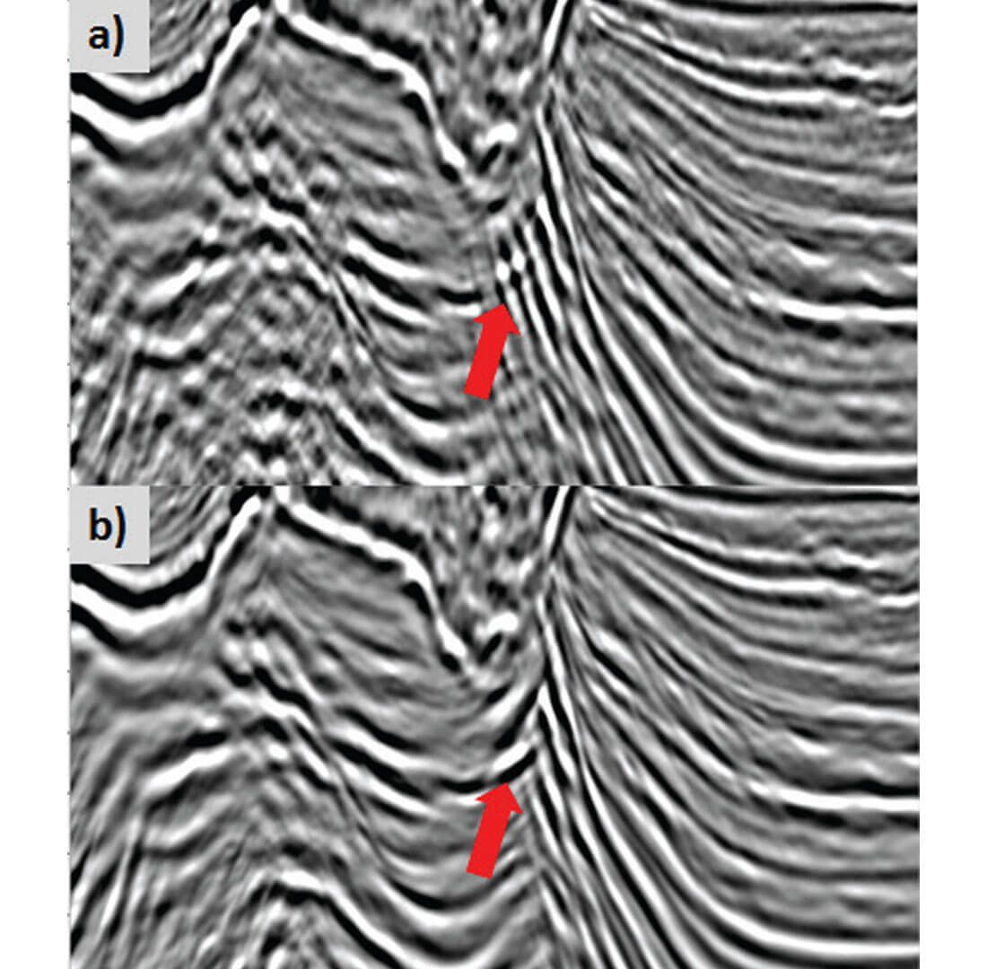
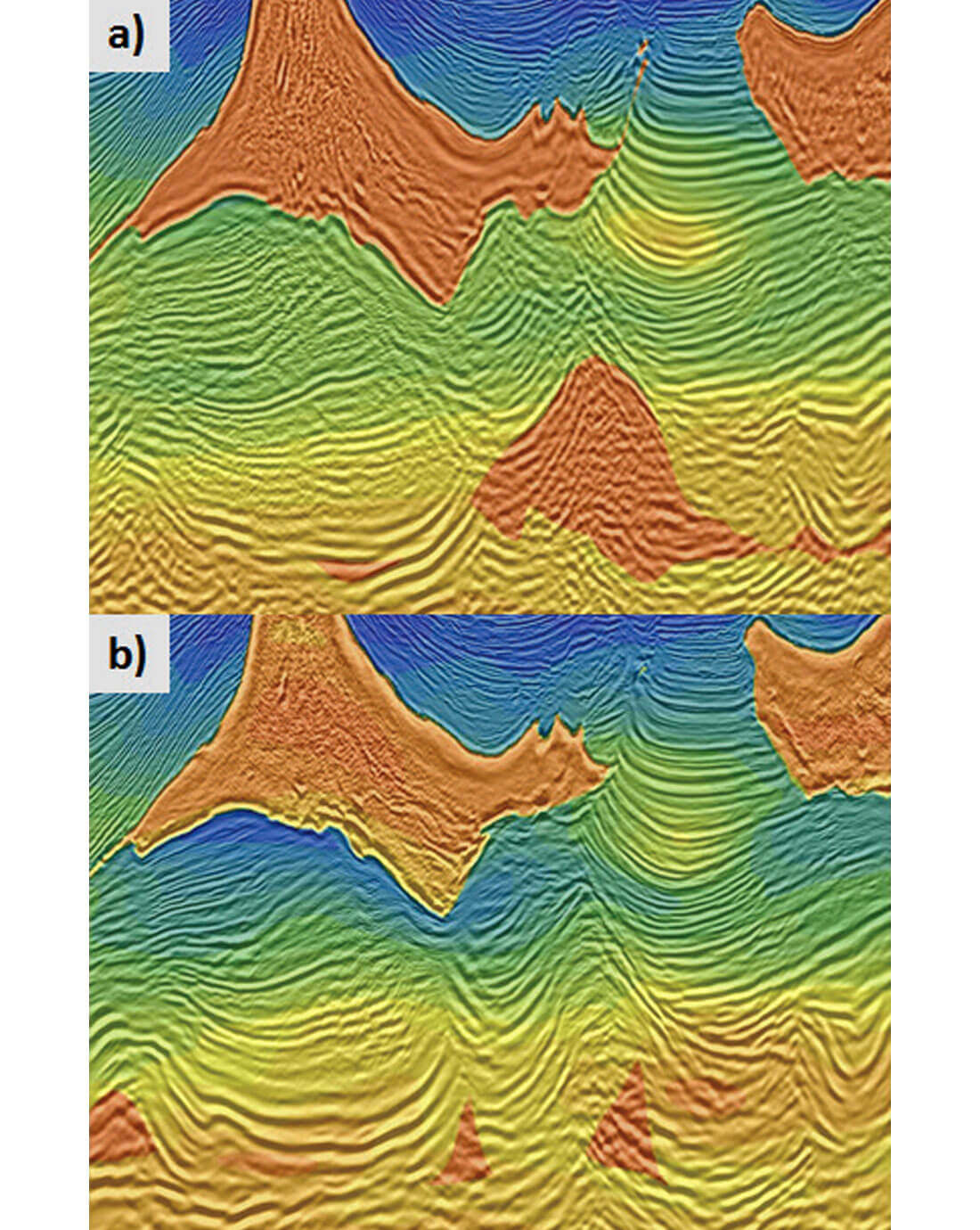
Image Comparisons
Finally, we compare the new images to previous processing efforts. The previous processing combines the orthogonal surveys before migration utilizing a method called common focal point regularization (Cai et al., 2012). The method involves wavefield redatuming to combine and regularize the component surveys. The sediment velocity model was mainly updated by successive iterations of Kirchhoff prestack migrations to generate gathers and tomographic velocity updates.
In this study, we update the salt and subsalt velocity using COR gathers and tomography, and then we run RTM, output 9 partial images, and generate target-image directional image stacks for each orthogonal survey. The two images are summed utilizing coherency weights (DDIS). The postmigration processing involved applying amplitude Q compensation. We observe that a) the base of salt is better focused, b) the subsalt image and salt geometry show enough changes to warrant evaluation and reinterpretation of the survey and c) the subsalt velocity model conforms to the seismic events. Also, the velocities below salt are slower and better correlate to nearby well information.
Conclusions
The application of common offset RTM gathers to update salt and subsalt velocities combined with DDIS stacks produces more accurate and significantly improved images without incurring the cost of acquiring new seismic data. The subsalt structures show substantial changes that may lead to new discoveries.

Acknowledgements
The authors would like to thank TGS and WesternGeco management for permission to publish this work. We also would like to thank our colleagues Hao Xun, Zhongyang Dong, Quincy Zhang, Purnima Bhowmik, Daniel Chaikin, Sidra Shahid and Connie VanSchuyver.


Join the Conversation
Interested in starting, or contributing to a conversation about an article or issue of the RECORDER? Join our CSEG LinkedIn Group.
Share This Article