Shallow groundwater is often hosted in Quaternary sediments that are very complex in nature and challenging to map. Traditional mapping and exploration methods to delineate these features are often time consuming, costly, and provide uncertain results. Airborne electromagnetic (EM) techniques have proven effective in delineating these aquifers over extensive geographic areas in a very timely and cost effective manner.
Brion Energy Corporation (Brion), in collaboration with DMT Geosciences Ltd. (DMT), has employed these techniques to identify shallow groundwater sources near our assets. Once these sources have been located, more traditional methods have been employed to verify and assess the aquifers. Some paleo-channels are often complex in shape and can pose additional challenges when drilling. For these circumstances, additional relatively low-cost ground-based EM methods (Time-Domain Electromagnetics, or TDEM) can be applied to confirm a shallow aquifer drilling target to improve drilling and well testing success.
Introduction
Steam assisted processes for oil recovery are becoming more common. The water necessary to generate steam for these processes is 0.26 barrels for every barrel of oil produced (CAPP, 2016). It is therefore important to identify groundwater supplies sufficient to meet these water needs. One very important source of water is groundwater in Quaternary aquifer systems. Since 1996, the Government of Alberta has conducted studies of these aquifer systems in the Northern Athabasca Oil Sands area, (Andriashek, 2001; Andriashek and Atkinson, 2007) with the result shown in Figure 1. Further and more accurate delineation of the aquifer systems through a combination of airborne and ground geophysics can benefit drill targeting and lower the overall cost of defining a water supply.
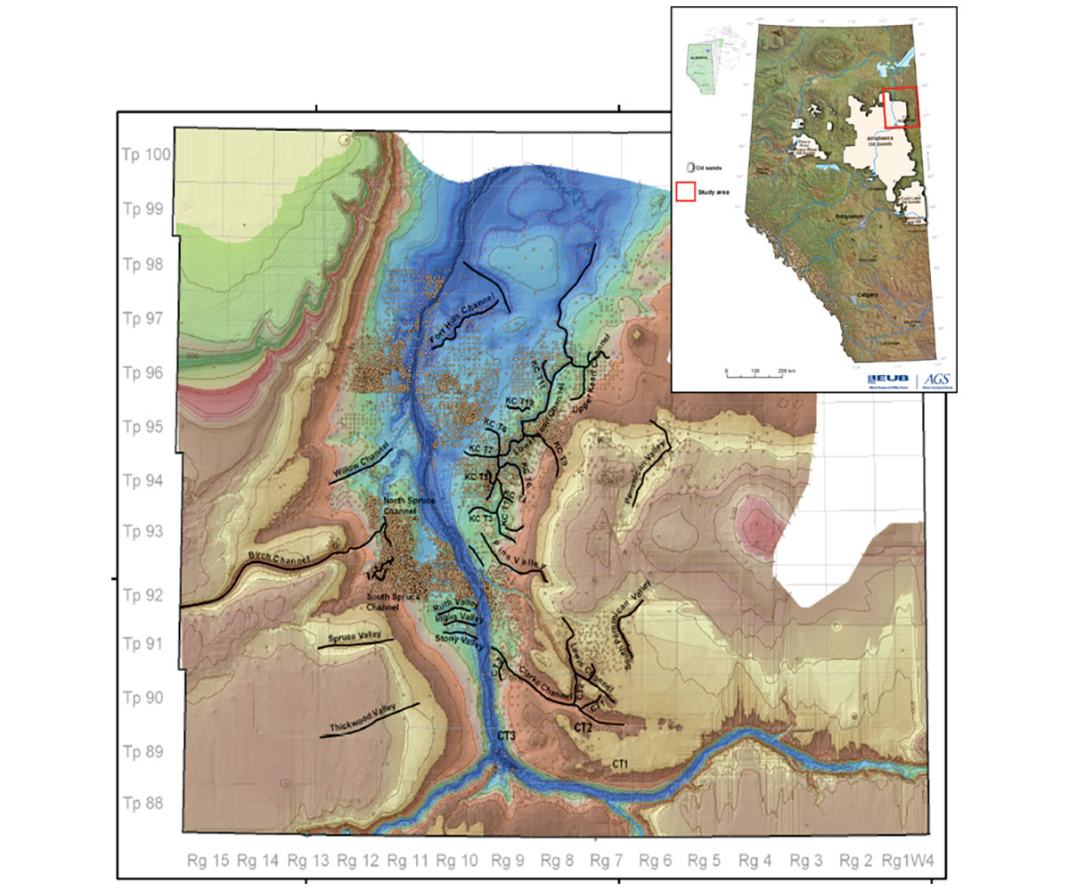
Ideal water sources are in the form of confined aquifers as they provide the best and most reliable sources. Identifying these water sources presents particular challenges in this area because the aquifers are generally in the form of buried channels, either incised into bedrock, or nested in glacial drift (Andriashek, 2007). These channels are narrow and can flow against the trend of modern surfaces, making them difficult to detect and map using exploration drill data. The variability in density of drilling provides good control on channel location and properties in areas coinciding with a drilled resource, but very poor control in the surrounding area, as seen in Figure 2. The result is that many channels remain undetected, or incorrectly mapped. Alternative methods such as remote sensing have been recommended (Andriashek, 2007).
Geophysics has been proven to be an effective tool in groundwater exploration and mapping. A wide variety of techniques have been used including reflection seismic (Bachrach and Nur, 1998), electrical resistivity, electromagnetics and more recently nuclear magnetic resonance (NMR) and complex conductivity. The type of survey used depends both on the physical property of the target and the scale of interest. Electromagnetics has proven a very useful technique for mapping potable water aquifers as well as saline aquifers (McNeil, 1991). The fact that electromagnetic surveys can be conducted in boreholes, on the ground, and in the air allows for a combination of similar data at varying scales and can therefore improve cost effectiveness.
DMT Geosciences Ltd (DMT) worked with Brion Energy Corporation (Brion) to plan a series of geophysical surveys to map buried Quaternary deposits to detect potential groundwater sources. From 2008 to 2015, Brion and DMT conducted a series of airborne and ground geophysical surveys to map the Quaternary channels/deposits within Brion’s lease area both refining and expanding the western limits of the study area (deLuca, 2015). The project involved a combination of airborne electromagnetics, ground electromagnetics, and drill data to cost-effectively develop an understanding of optimal drill locations for potential water sources at multiple scales.
Methods
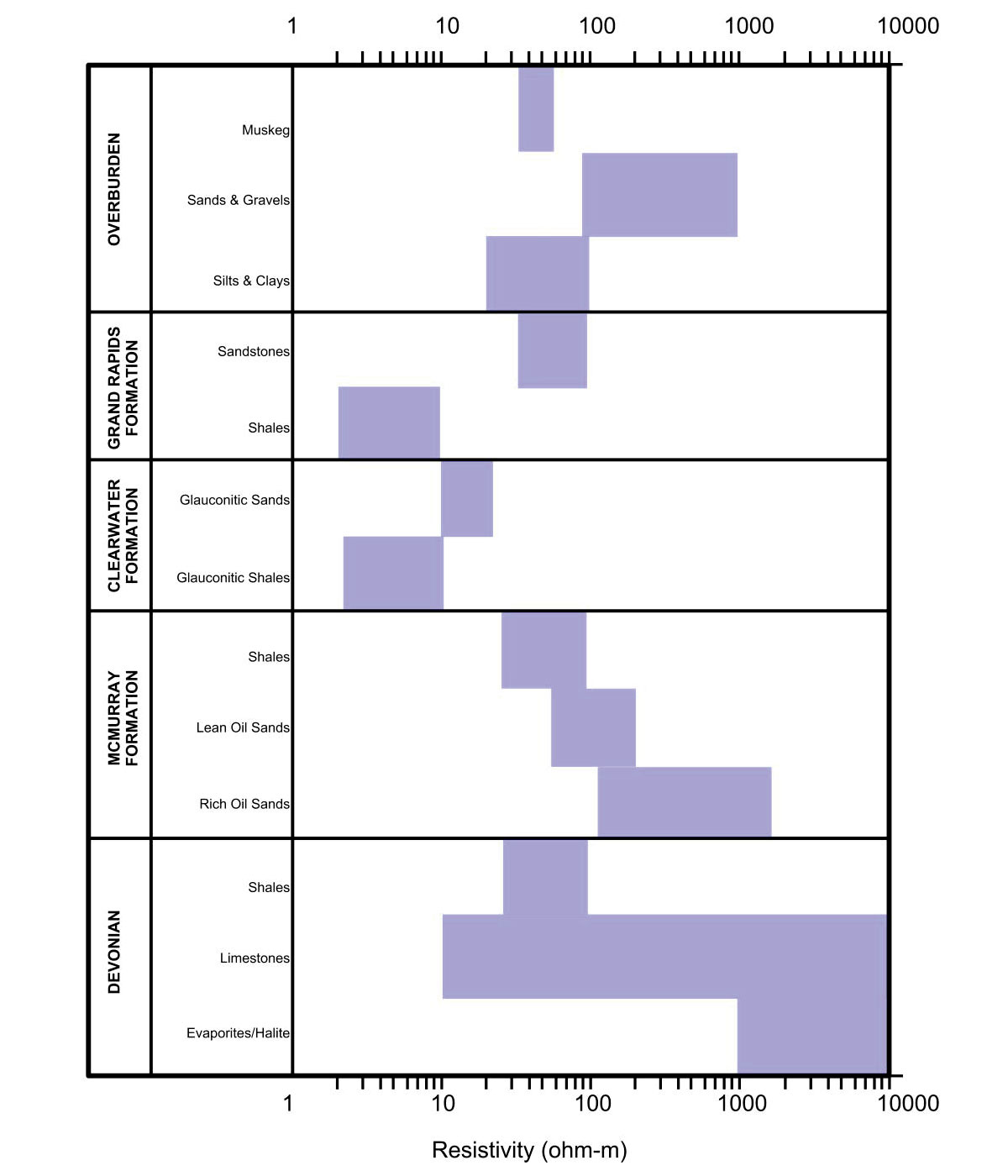
The electrical conductivity of ground materials in the study area varies from about 3 to 10000 ohm-m as shown in Figure 3. The presence of conductive pore water can affect the overall formation resistivity; however, in general, coarse grained materials such as those in aquifers are electrically resistive compared with the fine grained material in aquitards. This contrast in electrical properties between aquifers and aquitards presents a good geophysical target.
Airborne systems appropriate for aquifer/aquitard mapping can be either frequency- or time-domain electromagnetic systems. The system chosen must balance the higher resolution of the frequency-domain systems with the greater depth of exploration of the time-domain systems. In many instances, as is the case for the Brion project, a combination of both is required to fulfill all objectives. Recent developments in dual moment time-domain systems have allowed for single systems to collect information in both the shallow and deep intervals, which further increases the value of airborne surveys.
The choice of ground surveys to follow-up on airborne targets includes electrical resistivity tomography (ERT), time and frequency-domain electromagnetics. Ground frequency-domain surveys do not generally have the depth of investigation required for aquifer mapping and so were excluded from consideration. Electrical resistivity surveys were considered, but rejected for a number of reasons. In order to obtain data to the required depth of 150 m, an electrical resistivity survey has a required array length of approximately 600 m. This makes for an expensive survey. Additional costs would be incurred due to the difficulty of collecting resistivity data on frozen ground which can cause contact resistance issues. Contact resistance issues can be overcome in winter surveys, but it is a time consuming and expensive process.
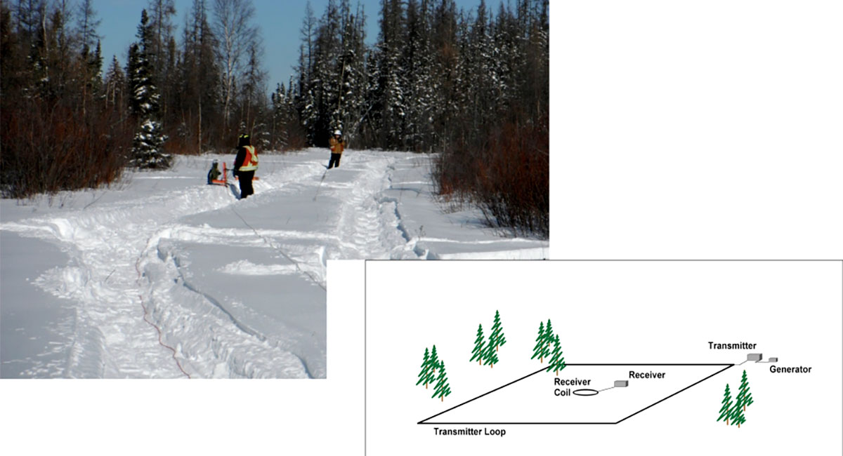
The decision to collect ground time-domain electromagnetic data (TEM) instead of electrical resistivity was based upon a number of factors. Ground TEM surveys are not dependent on summer conditions but can be collected 12 months of the year. TEM surveys do not require the level of ground clearing needed for ERT or seismic surveys thereby decreasing costs. By collecting centre loop soundings, as illustrated in Figure 4, a series of vertical readings of electrical properties can be achieved – in effect virtual borehole logs, albeit with greater volume averaging than with logging tools.
Results
Airborne
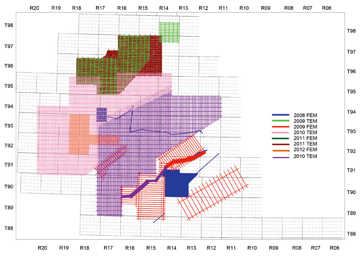
A total of seven airborne surveys were conducted for Brion Energy between 2008 and 2011. Although all surveys were used in the regional groundwater exploration initiative, each survey also had other primary objectives, including mapping of shale formation top, rich and lean resource delineation, and borrow pit prospecting. The type of survey was either frequency-domain electromagnetics (FEM) or time-domain electromagnetics (TEM) depending on the objectives. In general, if the depth range of interest was 100 m or less, the FEM system was used. In areas with a deeper objective, a TEM system was used. In some cases thick fine grained units, such as the Clearwater Formation, required that a TEM system be used even for investigation in the upper 100 m. In some areas, both systems were flown in order to get the resolution at shallower depths, but have the deeper penetration of a TEM system. The majority of surveys were helicopter- borne, though a few were fixed wing. The fixed wing systems are less expensive, but must be flown with a greater terrain clearance and so have poorer resolution. A map of the location and type of surveys flown is in shown in Figure 5.
Each survey was processed and interpreted for a variety of objectives including formation boundary mapping, aggregates, and potential for water resources. A compilation of all surveys was created to determine the regional distribution of potential water resources and is shown in Figure 6. The complexity of the paleo-channels in the region can be clearly seen in this image.
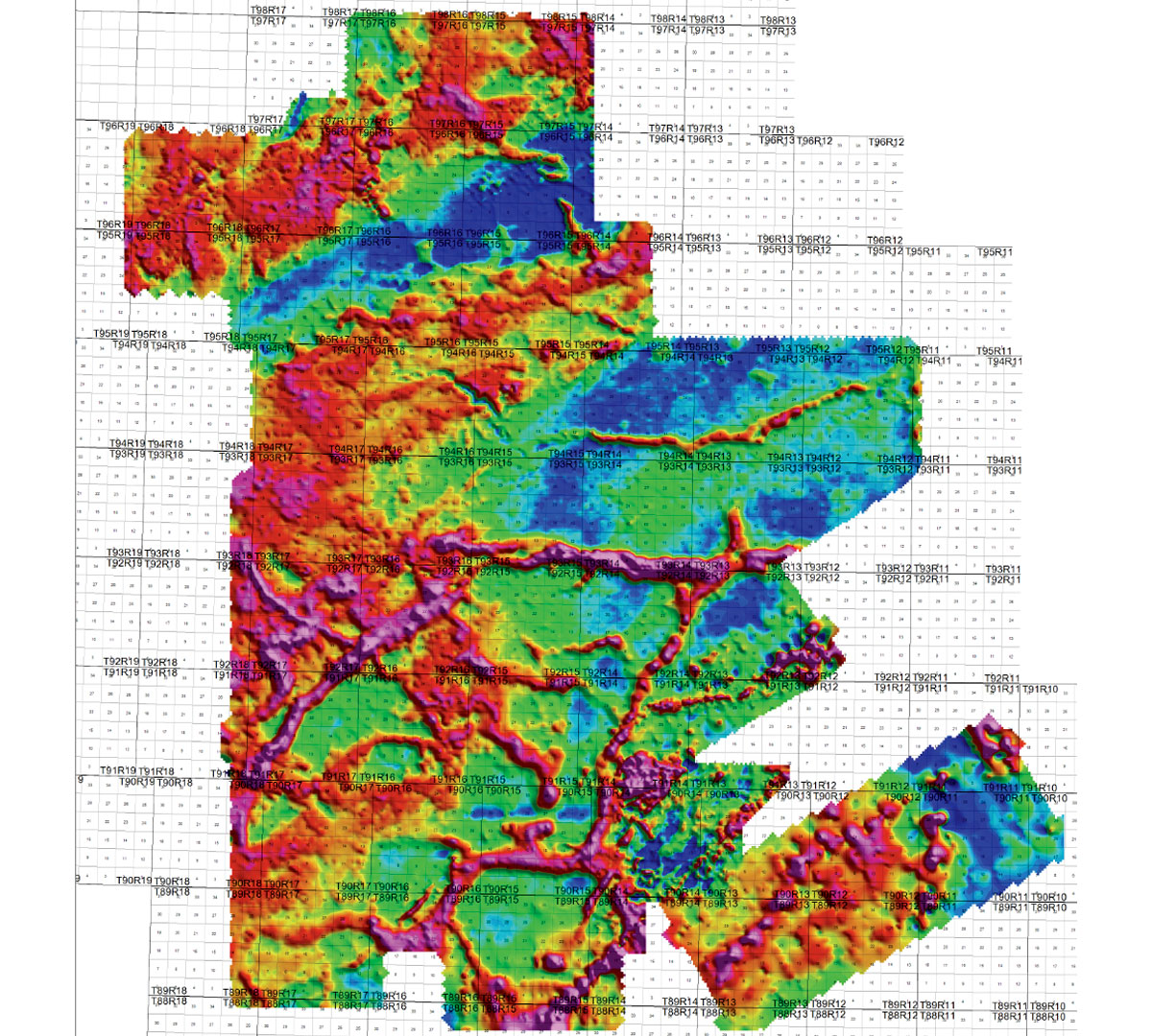
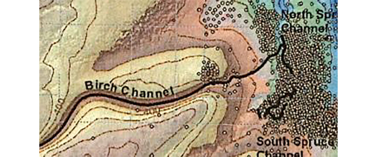
Comparison with the paleo-channels from the Alberta Geological Survey (AGS) work, which is based on boreholes and surface expression, shows much more complexity in the airborne data with channels diverging in some locations from the AGS interpretation (Figure 7). The mapping of the Willow Channel is extended to the west from the airborne surveys. The interpretation of the Birch Channel diverges significantly from the AGS work based on the airborne results. Additional side channels are also imaged in the airborne survey which could not be mapped from the sparse drilling available.

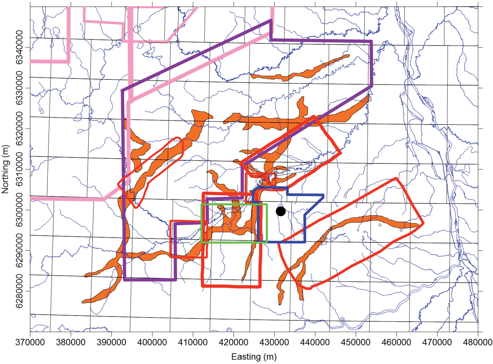
Airborne surveys provide a relatively inexpensive means of accurately mapping the complex distribution of paleo-channels in the region. However, the resolution of airborne data is often not sufficient to identify more detailed information such as the specific shape of the channel and the distribution of coarse grained sediments within the channel. This information is critical for targeting the most prospective area of a channel. Brion combined the airborne results with supporting drill data to produce a map of channels in their specific area of interest (Figure 8) (DeLuca, 2015). Based on the regional map of paleo-channels, hydrogeologists identified sections of the channels which warranted further investigation. The next scale of information was provided by ground electromagnetics.
Ground TEM
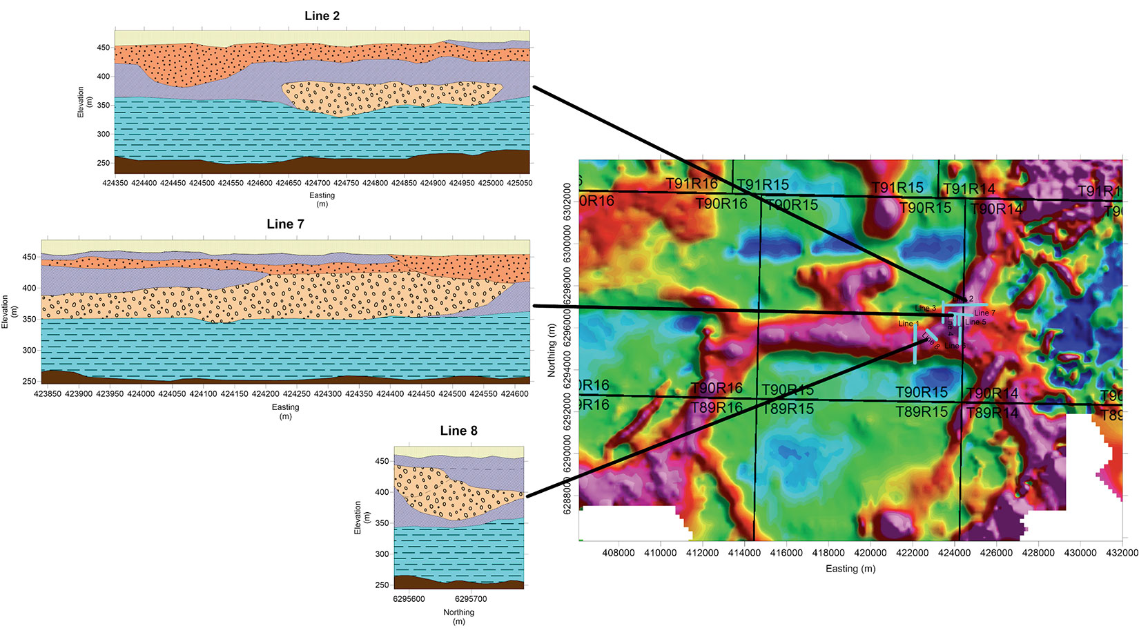
For the ground electromagnetic survey, 8 lines of ground TEM were collected. The data from these lines were processed and interpreted to more clearly identify the shape of the channel and to identify the location of coarser grained sediments. The results show variations in resistivity within the channel as well as the varying shape of the channel from line to line (Figure 9). The information in the TEM cross-sections provided the hydrogeologists with a better understanding of the channel and enabled better targeting of drill holes. The integration of down-hole measurement of physical and hydraulic properties from follow-up drilling with resistivity enables a more accurate and complete hydrogeologic model of the channel complex than using airborne EM data alone.
Discussion and Conclusions
A cost-effective investigation of groundwater resources can be conducted using air and ground electromagnetics in combination with well log data. This combination of data from different scales is an efficient methodology to construct a realistic groundwater model. Airborne surveys are relatively inexpensive per kilometer of data and provide an excellent regional picture of the hydrogeological setting. For example, one airborne study of approximately 400 km2 was approximately 40% of the cost to drill a single water well. Ground geophysics, using the airborne data as a guide, provides a more detailed view of the areas of interest and aids in both an understanding of the overall channel structure, and in targeting drill holes. The entire ground TEM survey was approximately 20% of the cost to drill a water well. Geophysical measurements in boreholes serve to calibrate the airborne and ground geophysics, enabling a link between the EM methods and hydrogeological parameters.
While the methodology suggested here has many strengths, including minimal land disturbance and high value for data cost, there are some limitations which should be considered. Inversion and interpretation of the data can suffer from equivalency issues and requires a priori information such as drill data to constrain the resistivity models. All EM methods suffer from interference from local infrastructure such as power and pipelines. This can limit data usability in some areas.
We conclude from this six-year study that an efficient methodology for mapping and assessing groundwater involves a variety of scales of surveys: using airborne geophysics, ground geophysics, before finally drilling.


Join the Conversation
Interested in starting, or contributing to a conversation about an article or issue of the RECORDER? Join our CSEG LinkedIn Group.
Share This Article