The South African National Roads Agency Ltd (SANRAL) appointed AECOM SA (PTY) Ltd (AECOM) in August 2014 to investigate the viability of constructing a proposed ring road around the town of Ermelo, in the Mpumalanga Province, South Africa. Coal mines have been operational in Ermelo since the mid-1800s, the majority of which have been abandoned. A portion of the proposed route around the northeastern part of the town was undermined, but, since little information was readily available about the undermining, a decision was taken to evaluate the planned route across the undermined area for old mine voids (tunnels and cavities) using airborne and ground geophysics, followed by drilling. This would assist the SANRAL engineers in determining whether the planned route was safe.
Experience with old coal undermining areas indicates that voids can potentially be filled with Acid Mine Water (AMW). AMW’s low pH makes it conductive. The air-layer above it is resistive. VTEM™ helicopter time-domain electromagnetic (TDEM) and aeromagnetic surveys were employed to survey the large planned area swiftly. This was followed by ground-based TDEM, electrical resistivity tomography (ERT) and gravity surveys. This methodology aimed to identify target areas inside the survey area for additional investigation using ground methods, while eliminating areas that were considered stable. Undermined targets within 100 m of the surface were successfully verified by drilling.
Our paper presents the airborne electromagnetic and magnetic results from the Ermelo Ring Road survey, as well as the ground geophysical and drilling data, focusing on one of the more important line-segments in the survey region. To our knowledge, the Ermelo survey is one of the few examples where airborne and ground geophysics were successful in assessing risk from coal undermining for roadway planning.
Introduction
In 2014, SANRAL (South African National Roads Agency Ltd.) investigated the viability of constructing the proposed Ermelo Ring Road, or Ermelo bypass. The town of Ermelo is situated in the Mpumalanga Province (Figure 1a) and is the educational, industrial and commercial centre of the 7,750 km² Gert Sibande District Municipality. The main activities in the district are mixed farming and mining (anthracite, coal and torbanite). Ermelo is at the confluence of three national highways, the N2, N11 and N17. Only the cities of Pretoria and Johannesburg are crossed by more in all of South Africa. The traffic volume passing through is extremely high which has prompted SANRAL to plan the Ermelo Ring Road, allowing traffic to pass around Ermelo (Fourie et al., 2015; Damhuis et al., 2016; Legault et al., 2017).
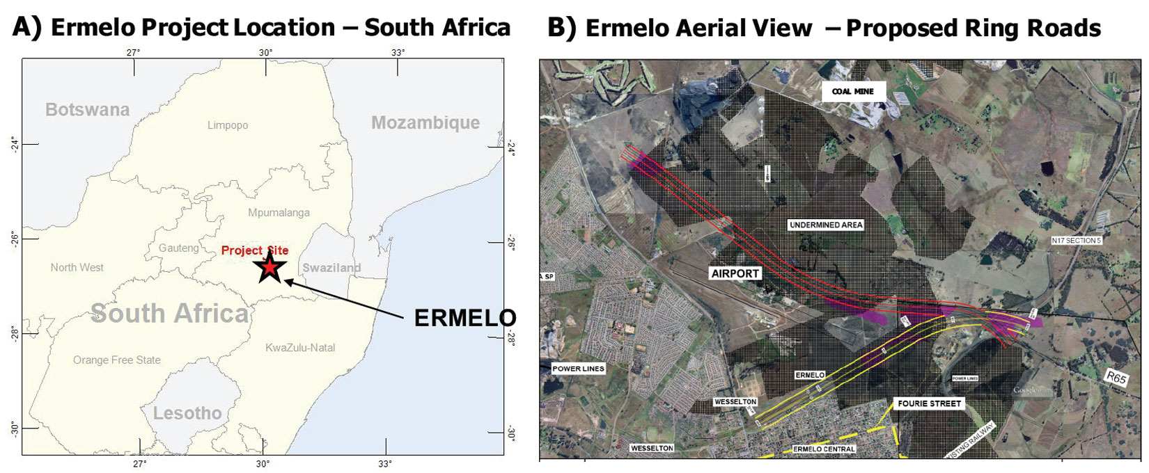
The planned ring road would cross previously undermined areas, a result of coal mines thought to be operational since the 1840s, the majority of which have been abandoned. A map showing the suspected areas of undermining is given in Figures 1b and 2. The areas indicated as “undermined” were based on general undermining, and the boundaries were not considered accurate.
Since the impact of undermining would be significant for the ring road, and very little information was readily available, SANRAL, with the help of AECOM SA (PTY) Ltd., took the decision to evaluate and investigate the planned route across the undermined area to understand the extent of undermining in terms of existing cavities or voids, thus determining whether the planned route was feasible. A geophysical methodology was proposed that combined airborne geophysics (time domain electromagnetics and magnetics, ground geophysics, drilling and borehole geophysics) to investigate the subsurface using survey lines along the planned route affected by undermining (Figure 2).

Geology
Regionally, South Africa’s coal deposits occur in rocks of the Karoo Supergroup, a thick sequence of sedimentary rocks deposited between 300 and 180 million years ago. The coal seams occur in a division of the Supergroup known as the Ecca Subgroup, which consists of sandstones and mudstones, together with coal seams, which were deposited in large river deltas that entered the ancient Karoo Sea. The Ermelo coal field, situated in the southeastern Mpumalanga Province east of Johannesburg, contains a large percentage of the nation’s recoverable coal reserves (McCarthy and Pretorius, 2009).
The geology in the vicinity of Ermelo is comprised of rocks of the Karoo Supergroup, and mainly consists of sandstones, gritstones, shales and coal beds of the Ecca Subgroup, made up of the Volksrust and Vryheid Formations. The sediments of the Ermelo district are intruded by dolerite sills and dykes of variable thickness (Van Schoor and Fourie, 2015).
Acid Mine Water
Sulphuric acid is formed by the reaction of water with iron sulphides, particularly the mineral pyrite, which is a common constituent in coal seams. Sulphuric acid may be produced from the drainage of mines from which sulphide ores are being extracted, from tailings produced in plants where the ores are processed, or through groundwater emerging from abandoned mines charged with sulphuric acid and various salts of metals. Once acid mine water (AMW) has been formed, it will remain or accumulate in the rock by filling pores, or be removed by water. The AMW’s low pH makes it conductive, which lends it to be an excellent target for TDEM and resistivity surveys (Paterson, 1995). In contrast, groundwater chemical tests from the boreholes in the Ermelo region are generally of high-normal pH (8-9) and resistive (1000-7000 Ωm) rather than conductive, which indicate that AMW contamination is not widespread in the Ermelo groundwater system (Fourie et al., 2015).
Geophysical Survey Results
Airborne Geophysics
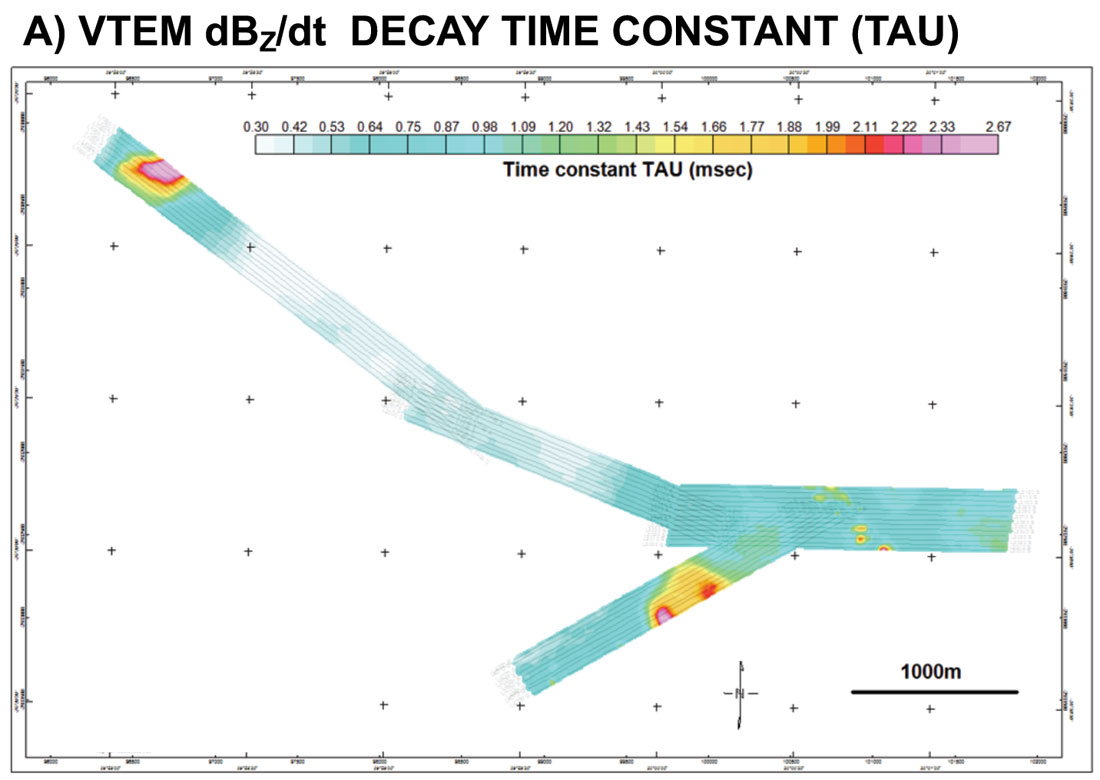
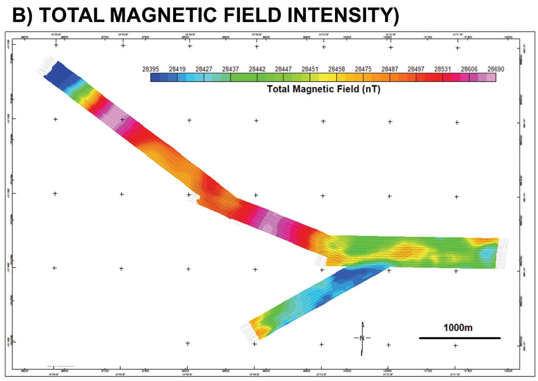
The geophysical surveys consisted of a helicopter borne EM using the Versatile Time-Domain Electromagnetic (VTEM™Plus) system with streamed full waveform data recording (Legault et al., 2012) and including a caesium magnetometer. The VTEM™ was flown along four survey strips (B1-B4 – Figure 2) in the region of the proposed ring road. A total of 86 line-km of geophysical data were acquired along 9 sub-paralleling profiles (Figure 2) using a flight line spacing of 30 metres. The VTEM™ secondary field EM and aeromagnetic survey results across the Ermelo region are presented in Figure 3. The late channel (off-time) EM decay constant image (Figure 3a) highlights areas of low and high electrical conductivity (low and high tau) that either represent conductive shale units or potential regions of AMW in undermined areas. The total magnetic field intensity (Figure 3b) defines areas of low and high magnetic susceptibility that represent potential fault-hosted dolerite dyke intrusions.
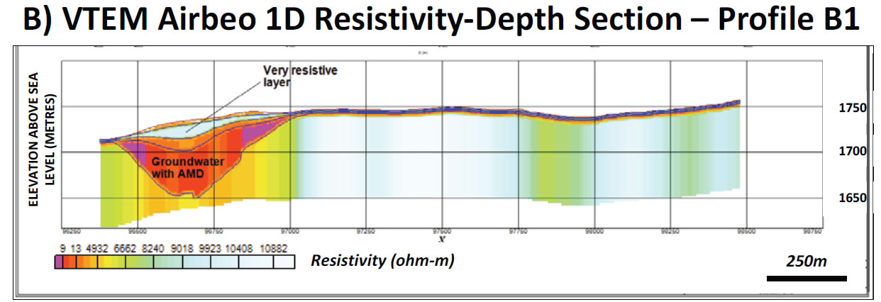
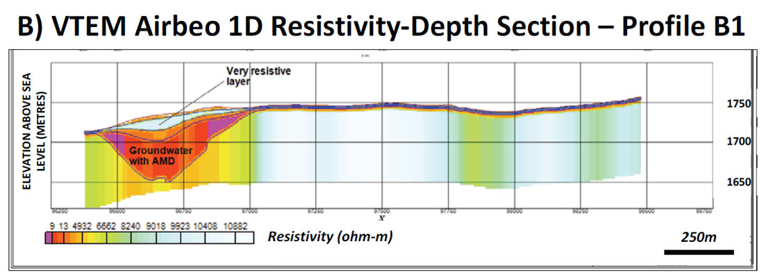
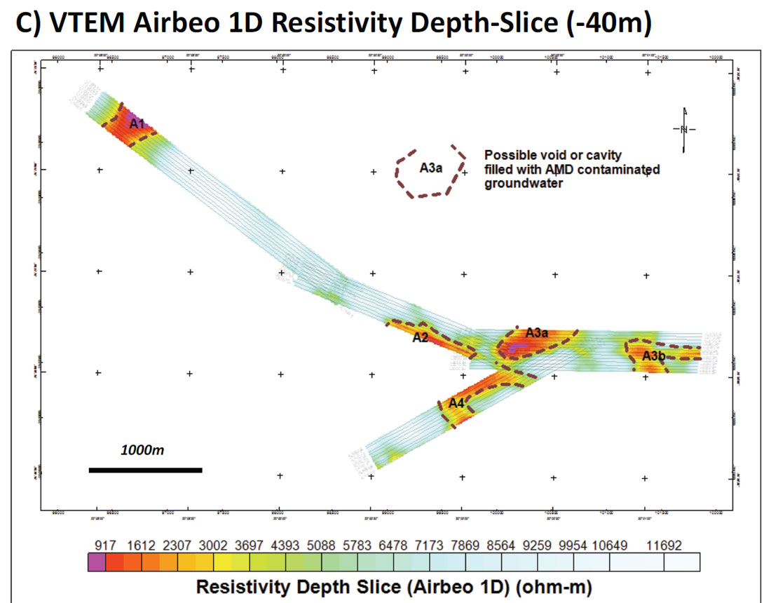
The airborne TDEM results were interpreted using the AMIRA Airbeo 1D layered-earth inversion code (Raiche, 1998) and a five-layer initial model that included a conductive fourth layer (20 Ωm by 20 m thick) that simulated the void or cavity flooded with Acid Mine Water (AMW) that is the layer of interest. Figure 4 presents a cross-sectional view through L1060 from profile B1 that highlights conductive anomaly A1, interpreted as a possible cavity filled with AMW groundwater and capped by a resistive void at surface. Figure 4c presents a resistivity depth slice extracted from all four survey blocks (B1-B4). It shows that the VTEM™ data across a major section of the proposed route reveals no undermining. It also highlights five conductive anomalies that potentially represent voids or cavities (A1, A2, A3a, A3b and A4) filled with AMW contaminated groundwater. These five anomalies were targeted by ground investigations and drilling. The remainder of our paper will focus specifically on block B1 that hosts the A1 conductive anomaly.
Ground Geophysics
Ground geophysical surveys, consisting of central loop TDEM, resistivity tomography (ERT) and gravity, were performed over several traverses located on the long axes of blocks B1 to B4 as ground follow-up to the airborne EM survey (Lotter and Du Toit, 2015). The ground geophysical program was designed to obtain maximum resolution between 10 m to 80 m depth, in order to identify and delineate areas of undermining, specifically open cavities. Nine exploratory boreholes were later drilled, to 90-120 m depths.
The ground TDEM employed a similar in-loop or central loop configuration and similar transmitter base frequency (25 Hz) as the airborne VTEM™ system. The ground TDEM used 50 m by 50 m transmitter and 20 m by 20 m receiver loops, and measurements were obtained at 10 m intervals. The TDEM survey was conducted along the central line of the VTEM™ survey for each survey block. Conductive anomalies identified by the TDEM surveys were expected to be undermined areas with AMW, but could also be sub-vertical faults, weathered dolerite dykes, or carbonaceous shales-mudstones of the Ecca Subgroup.
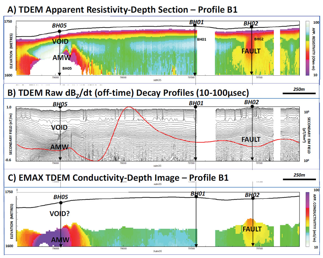
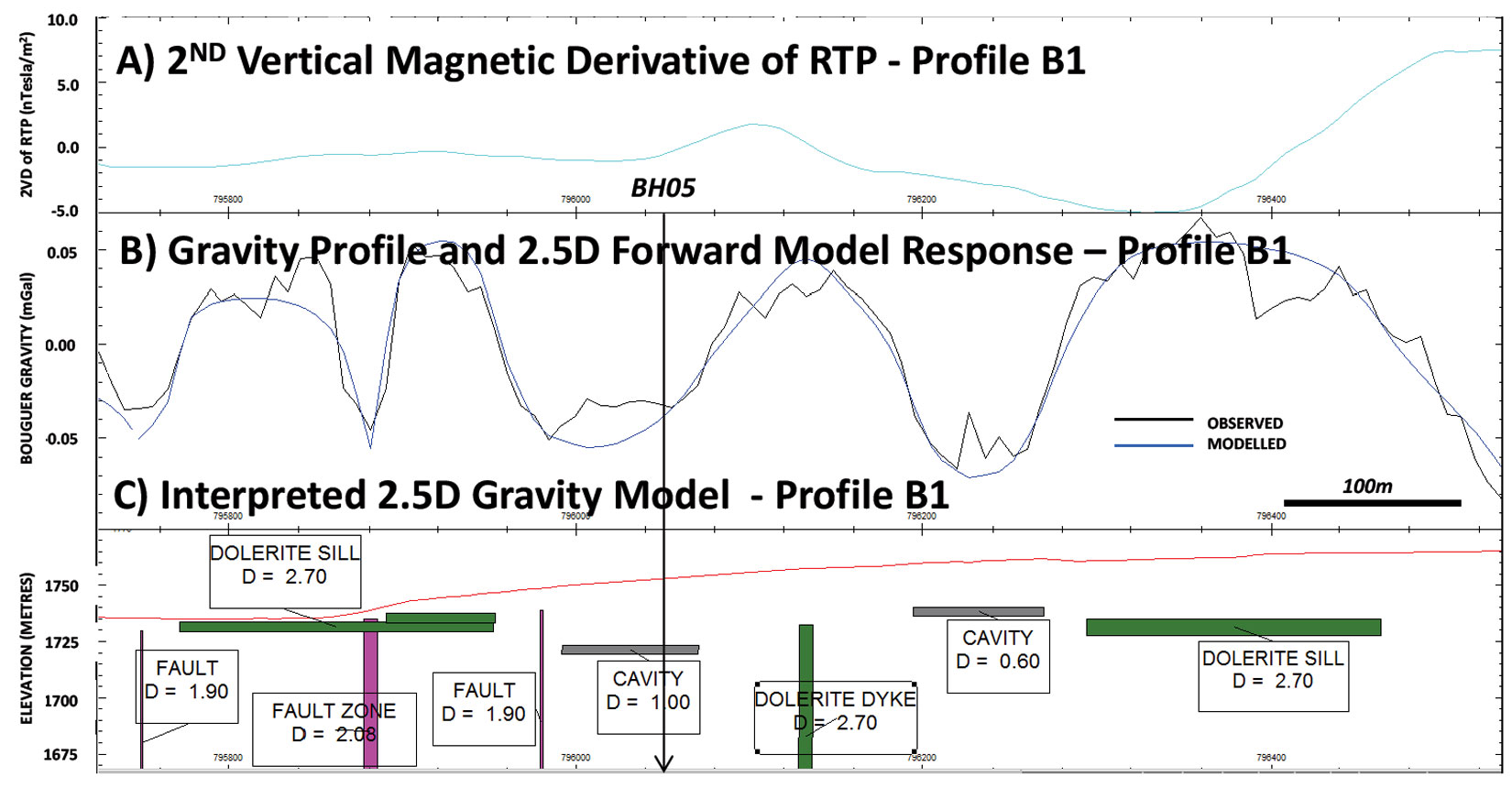
Figure 5 presents TDEM results for profile B1, showing a surficial resistor above a deeper, flat-lying conductor that is consistent with undermining and AMW. The results of BH05 indicate a 4 m thick cavity at 25 m which correlates with the top of the resistive zone. The deeper conductor is explained by contaminated, conductive groundwater. A second conductor intersected by BH02 is explained by fault-fracturing, possibly from a flooded shaft. The very diagnostic EM response over BH05, indicating an anomalously fast decay associated with very resistive layer near surface, is a very powerful tool to recognize or identify undermining in the near-surface zone (0-30 m depth). This particular type of response was only observed at one other location for the Ermelo Ring Road project.
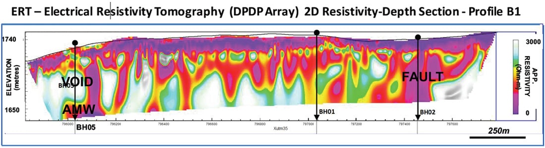
The electrical resistivity tomography (ERT) survey used a roll-along array with 10 m dipole spacings and both Wenner and dipole-dipole array configuration. The ERT traverses were conducted coincident with the TDEM survey lines. ERT was chosen for higher sensitivity to resistivity contrasts than TDEM and its ability to map cavities and voids not flooded by AMW (i.e., resistive), as well as resistive, fresh dolerite dykes and coal seams. The ERT results were interpreted using the Geotomo’s RES2DINV inversion software. Figure 6 presents the ERT inversion cross-section for Profile B1. The main ERT anomalies correlated well with the TDEM derived depth sections, but there are numerous, other isolated high and low resistivity zones that can be interpreted as voids or flooded cavities.
Gravity profiles were designed to map gravity lows from undermined areas regardless of whether the cavity or void is filled with AMW or not. The gravity survey was conducted with a Scintrex CG5 model gravimeter with elevation and positioning control using a real time differential GPS system. Readings were taken at 10 m intervals, along the central VTEM™ survey lines (where possible) for the four target blocks. Simple tabular models were used for the gravity modelling and only flooded cavities, dolerite dykes and sills and faults were considered (Figure 7). The EM and ERT data supported the gravity interpretation and BH05 on line B1 intersected a cavity at 25m that was predicted by the gravity model (Figure 7).
Drilling and Borehole Logging
The results from the ground geophysics were to be used to identify possible drilling positions to verify targets or undermining. Nine exploratory boreholes, namely BH01, BH02, BH03, BH05, BH06, BH07, BH08a, BH08b and Bh10 (Figure 8) were drilled following the completion of the airborne and ground geophysical surveys. These were then logged by a geologist and water samples were measured for pH and conductivity.
Essentially sandstone was encountered within all of the boreholes, with minor thin coal seams and shale horizons, and sporadic occurrences of dolerite. Weathered and transported unconsolidated horizons were found generally in the upper 5-6 m, and competent sandstone occurred to the full depth of the boreholes (90-120 m). Cavities were intersected in BH6 between 90 m and 91m and, notably, within BH05 between 26 m and 31m, as predicted by the airborne and ground geophysics. Only one other TDEM anomaly with similar characteristics was detected near the southwestern edge of survey block B2. Borehole BH06 was situated on a gravity low and there were no TDEM or ERT data collected for this particular section. However, an airborne EM anomaly directly to the south of BH06 could be associated with AMW at depth, related to the cavity intersected, i.e., the intersected cavity possibly extends to the south.
Lastly, borehole geophysics was performed in selected boreholes and consisted of magnetic susceptibility, electrical resistivity and density, as well as an optical televiewer. Resistivity logging data confirms that the carbonaceous shale is relatively more conductive. Coal seams have lower density (<1 gm/cc) than the host. Coal seams are very resistive if sandwiched between resistive sandstones. The results show that the sandstone subsurface is intact and consolidated.
Risk Assessment
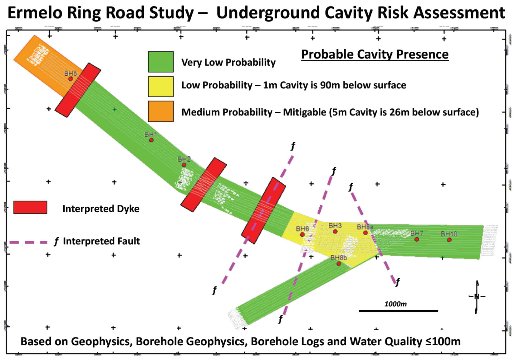
Based on the geophysical model, including the airborne, ground and down-the-hole geophysics, as well as the borehole logs, the inferred zonation for risk assessment for the undermined portion of the Ermelo Ring Road route was as follows:
- VLP (green) – Very Low Probability of Shallow Undermining (<100 m), characterized by consistent resistivity (high) and generally shallow groundwater <35 m with no evidence of AMW.
- LP (yellow) – Low Probability of Shallow Undermining (<100 m), characterized by deeper groundwater >50 m with no AMW.
- MP (orange) – Medium probability of Shallow Undermining (<100 m).
This information was used to indicate the probability that undermining is present at different sections of the route (Figure 8). The very low probability section (shown in green) was derived through the results of the geophysics (no anomalies) and was later confirmed by drilling.
The low probability section (shown in yellow in Figure 8) was derived through the geophysical data and drilling. A cavity was intersected at 90 m. Borehole camera data showed that the cavity is still intact with only very minor stress release cracks in the hanging wall. The hanging wall is comprised of a very thick concession (80 m) of very competent sandstone. The faulting in the area could have displaced the mined coal seam and the presence of the cavity, with the deeper groundwater level warranting this classification.
The medium probability (orange section in Figure 8) region indicates the area where the shallow larger cavity was detected which is 5 m in vertical extent and only 26 m below surface. The cavity warranted this classification.
Conclusions
The primary objective of the airborne and ground geophysics and drilling was to locate and determine the depth and condition (if possible) of any underground cavities for the Ermelo Ring Road Project. As a whole, the non-invasive airborne and ground geophysics, in particular, airborne and ground TDEM surveys and the gravity method were able to meet the objective satisfactorily. Drilling results have proved that the TDEM methods, combined with the gravity and ERT methods are most effective in locating the underground cavities. The airborne magnetic data acquired by the VTEM™ system configured with a magnetometer were also useful in identifying dolerite dykes and faults.
The airborne TDEM geophysical investigation showed that the data across a major section of the proposed route shows no anomalies. However, five areas of interest were identified (A1 to A4) and were surveyed in detail with the ground geophysical methods and subsequent borehole drilling.
Modelling showed that large portions of the surveyed area are not anomalous and are therefore inferred to be unaffected by shallow undermining. This was confirmed by borehole investigations. In contrast, detailed investigative work resulted in the detection of undermining, specifically in borehole BH05, where a predicted void of 5 m was intersected at 26 m. Not all the anomalies detected were due to undermining, but are instead related to geological structure, such as dykes and faults. All of this information needed to be evaluated to determine whether the proposed route was safe from undermining. This culminated in a risk assessment of the probability undermining on the proposed route.
The approach taken to investigate the indicated undermining by DMR for the proposed ring road at Ermelo has proved the following:
- That more than one geophysical method is desirable.
- The investigation must be performed in stages. The elevated investigation (airborne geophysical survey) has to be completed. It is quick and indicates the target areas that should be investigated in more detail.
- The target areas are then surveyed in detail by ground geophysics.
- Both the airborne and ground geophysics are employed to identify the drilling targets.
- Drilling is then carried out to confirm the geophysics (ground truthing).
- Logging of boreholes to determine geotechnical properties (integrity) of the geology.

Acknowledgements
We gratefully acknowledge SANRAL and AECOM for allowing us to present the Ermelo Ring Road study results. Cas Lotter and Peter Du Toit, from Geospec Instruments Ltd. carried out the ground geophysics and their modelling.
Related Reading


Join the Conversation
Interested in starting, or contributing to a conversation about an article or issue of the RECORDER? Join our CSEG LinkedIn Group.
Share This Article