Considering the challenging times in the Canadian oil and gas industry for the geophysical profession, this article will demonstrate the successful and value-added application of geophysics by a Canadian oil and gas company in Laos, Southeast Asia. The value added by geophysics is quantified by calculation of the oil and gas resources identified initially by seismic and geological mapping and independently assessed by a consulting engineering firm.
Laos, with a population of 7 million people, has more than 60% of the population living in some 9000 rural villages. Wood and charcoal are the main energy sources used for cooking and heating in these areas and any oil and gas is imported from Thailand and Vietnam at very high prices. Although industrialization has been historically minimal, Laos’ recent growth has been amongst the fastest in Asia, nearly 8% per year for the last decade. The recent economic drivers have been mining, logging, and construction. In conjunction with this growth, oil and diesel consumption has increased with the dramatic rise in the number of vehicles on the roads.
As Laos is still one of the world’s poorest and least-developed nations, the discovery of significant hydrocarbon reserves within the country could help alleviate the existing poverty, improve the quality of life and contribute to the economic independence of this land locked country.
Petroleum Potential of the Area
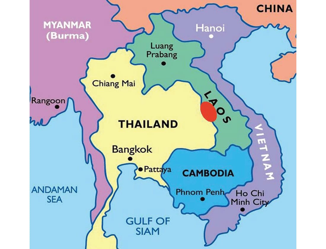
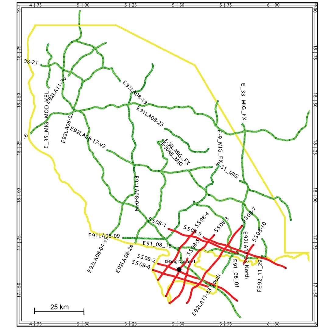
The location of the Laos oil and gas concession is shown in Figure 1. It is situated west of Vietnam and east of Thailand in the west central part of the country. The area of the concession is approximately 12,000 square kilometers and it is in the third year of a seven year exploration term. The concession was granted to CamCan Energy Limited of Calgary initially in 2014 by the Laos Government and has three exploration periods with manageable work commitments including seismic and wells. The closest gas production is 200 km to the west, from the SinPhaHorn gas field, in the Thai portion of the basin. This field was discovered in 1983 and currently produces 90 Mmcf/day. A total of 2600 km of 2D legacy seismic lines have been acquired over the area and have been integrated into the geoscience interpretation and mapping (Figure 2).
Only three wells have been drilled in the country to date, including one drilled on the concession. The exploration in the area started in the 1990s and has had three companies commit to geological field work, geophysical acquisition and minimal well commitments. The regional geology and stratigraphy work to date, as well as the drilling results on the Thailand side of the basin, support multiple prospective hydrocarbon bearing formations. These may include the shallower Jurassic/Cretaceous group of formations as well as the deeper Triassic to Permo-Carboniferous targets.
The structural regime is complex and reflects multiple episodes of compression, subsidence and erosion. As a result, the subsurface imaging and mapping has been a challenge in the past. However, it is this complex structural history combined with stratigraphy that leads to multiple opportunities for exploration prospects.
For example, the most recent well drilled in 2010 by Salamander Energy encountered methane, ethane and propane gas shows on the mud log in the Triassic, and a wet porous carbonate reservoir in the Permian. Oil seeps and bitumen staining have been noted in the Permian at surface to the east and north of this well. Currently, there are no plans to put this well on production until testing of the Triassic is completed and infrastructure is available to handle the gas.
Methodology
All of the 2D seismic lines were available for analysis in some form in the project area. As shown in Figure 2, the data consisted of mainly two vintages. The 1990s data is shown in green on the map and the 2008 data is outlined in red. The 1990s data had some original field data available, no original survey and only digital or paper copies of the final stacks to interpret. The 2008 data was fair quality data with digital stacks and survey information in the headers. For the field data that couldn’t be found, paper copies of the stacks were scanned to add additional information to the digital mapping. The survey information was fortunately captured at the top of most of the paper copies and became useful information to properly locate the seismic lines on the maps.
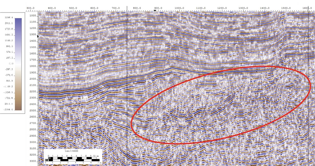
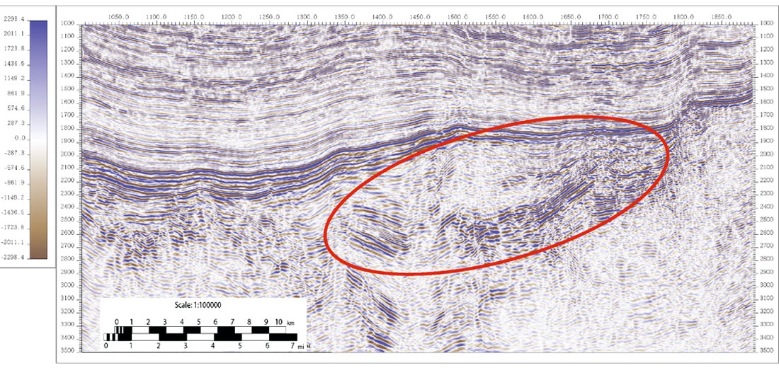
Examples of the 1990s stack data are shown in Figures 3 and 4. The Permian zone of interest is highlighted on the figures by a red oval. The data in these parts of the seismic sections are poor quality, noise-dominated and overlain by the higher reflectivity zones of the Jurassic and Cretaceous above. The original processing consisted of predictive deconvolution, basic refraction analysis, poststack Kirchhoff migration and f-x noise attenuation.
In order to reprocess this vintage of data the surveys had to be re-created. This was achieved by using old seismic interpretation maps found in the Laos government repositories. These maps had the original position of the seismic lines on them and only the common depth point (CDP) locations. The seismic acquisition reports from the government files indicated that this data was acquired with a Vibroseis source back in the early 1990s. This information was combined with images from Google Maps to reconstruct the line field locations and the corresponding survey coordinates. The surface elevations for the specific CDP locations were also extracted from Google Maps. With the survey information re-created, the data could be reprocessed, however, considerable shot-by-shot quality control had to be implemented as the exact vibrator point (vp) locations and potential vp skids were still unknown.
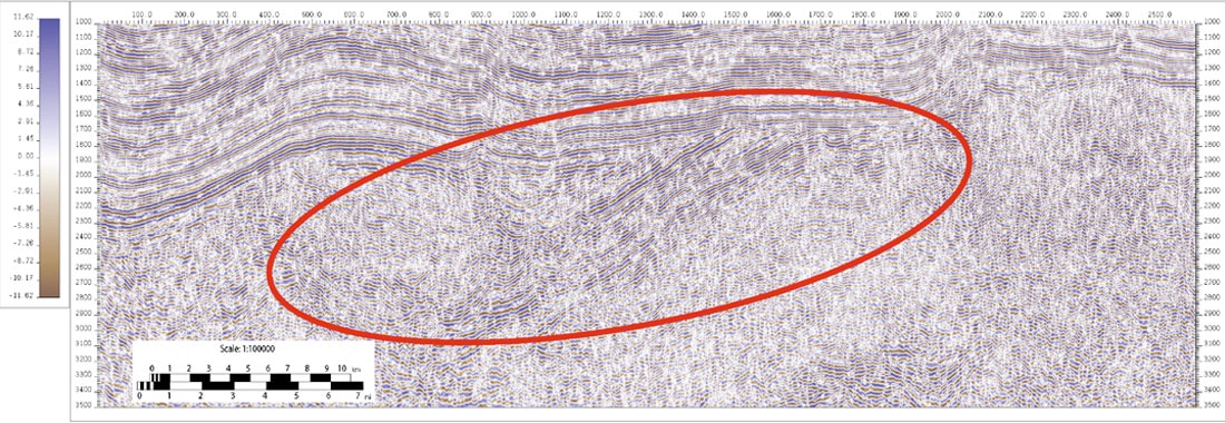
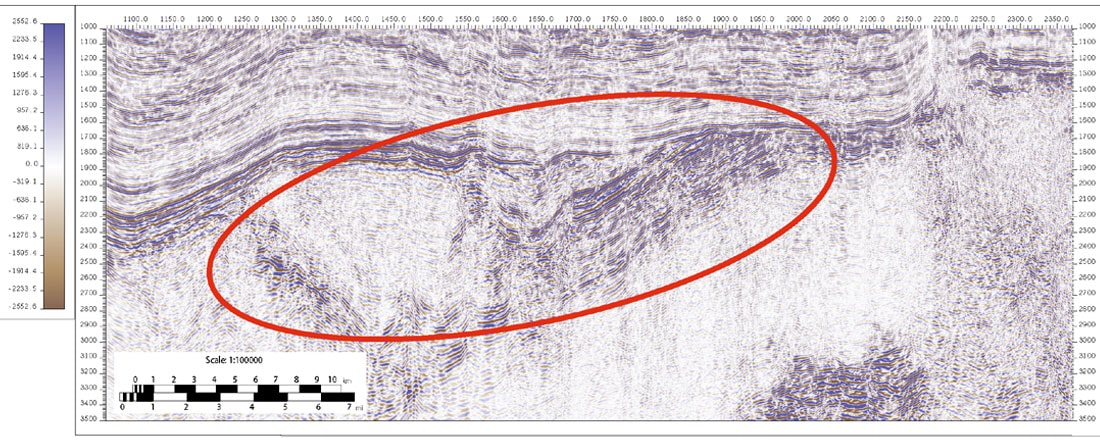
Examples of the recent reprocessing of the same lines are shown in Figures 5 and 6. The 2015 reprocessing included additional applications such as crooked line geometry, advanced noise attenuation, manual first breaks, advanced tomography, prestack time migration and spectral balancing. The resulting images show considerable improvement in the zone of interest in terms of signal-to-noise ratio and general image improvements of the basin structure, stratigraphy and architecture. On the east side of Figure 5, for example: there is clearer evidence of a large-scale fault present which contributes to the present-day trapping mechanism, as well as considerably more coherent signal at the Permian level and deeper. Figure 5 shows an early stage reef buildup that wasn’t evident on the earlier processing along an extensive carbonate platform.
There was considerable value added by choosing to reprocess the data in this innovative manner in terms of time and cost saved as well as less environmental impact. Not only did this the seismic data not have to be re-acquired in order to generate a more modern subsurface image, which would have caused considerable ground disturbance, it also provided a cost saving of approximately $2 million dollars to the operating company. From a time point of view, the exploration program could proceed in a timely manner because the data didn’t have to be acquired again in the field. Approval, permitting, and re-acquisition would have delayed the project an additional 1-2 years.
Results
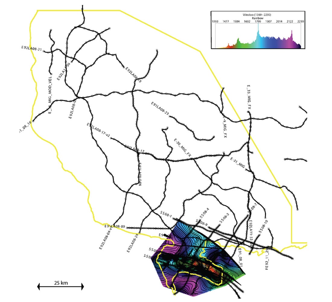
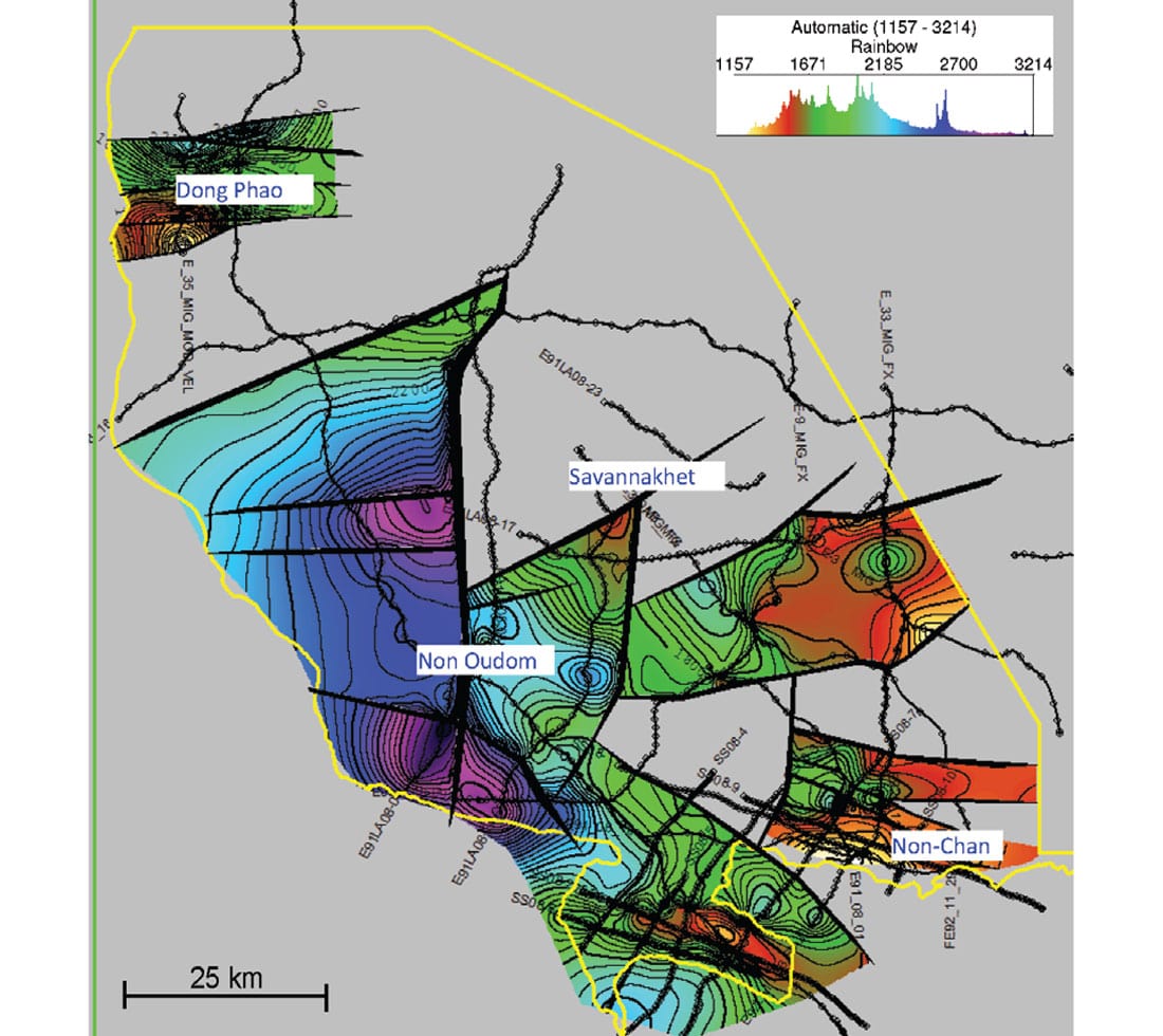
The mapping that was achieved before the reprocessing was carried out is shown in Figure 7. The information was limited to the 2008 data in the south west portion of the concession. One prospect had been previously recognized and drilled at that stage. The results of the recent updated mapping including the reprocessed data is shown in Figure 8. The updated mapping has added an additional 4 prospects of considerable impact and economic size. The improved imaging reduced the prospect drilling risk which improved the overall economics and project viability.
The project economics were carried out by an independent engineering company, incorporating the seismic and well data, geological reservoir parameters, engineering production estimates, as well as knowledge of the oil and gas price contracts for the area. The results of this assessment resulted in a P50 gross in-place gas estimate of 36 Tcf for the project. At a net present value of 10% this resulted in a current risked asset value of $847 MM US. These results are highly favorable due to the demand for natural gas in Thailand and anticipated industrial growth in Laos.
Conclusions
The reprocessing of the 1990s vintage seismic data in this innovative manner added considerable value to the project in a number of ways. Up to two years was saved in the limited seven-year exploration term by not having to re-shoot the 1990s data. Approximately $2 MM US was saved by not having to re-acquire the seismic data as well. Furthermore, there was no additional environmental impact or disturbance to the local towns and farmers as a result of re-processing the data.
The improved subsurface imaging resulted in an additional 4 prospects being mapped and generated, adding large amounts of quantifiable gas resources to the land holdings. These 4 prospects are Dong Phao, Savannakhet, Non Oudom and Non-Chan, as shown in Figure 8. These prospects were mapped using the seismic, which showed substantial fault bounded or independent structural closures at either the Triassic or Permian level. This gas resource was independently assessed having a risked asset value of $847 MM US.
Finally, if hydrocarbons are discovered in Laos, it will be the first commercial oil and gas production in the country and the beginning of their hydrocarbon independence from foreign entities. This can also lead to a decrease in poverty, an improved standard of living and increased economic independence for the country.

Acknowledgements
The author would like to thank CamCan Energy Limited for their support and permission to publish this article.
Related Reading


Join the Conversation
Interested in starting, or contributing to a conversation about an article or issue of the RECORDER? Join our CSEG LinkedIn Group.
Share This Article