Marine Geophysics at Dalhousie University
The current geophysical research programs at Dalhousie University are led by Christopher Beaumont, Keith Louden and Mladen Nedimović. Christopher Beaumont is a Professor in the Department of Oceanography and Canada Research Chair in Geodynamics (Tier 1). He is a globally recognized leader with a research program centered on quantitative modelling of processes associated with: 1) Extensional tectonics (formation of rifts and rifted continental margins, their sedimentary basins and associated salt and shale tectonics; 2) Formation of foreland basins and thick- and thin-skinned fold and thrust belts; 3) Orogenesis (cordilleran continental margins, continent-continent collision, formation and exhumation of ultra-high-pressure rocks, strain partitioning) and; 4) Interaction between surface processes and tectonics. Keith Louden is an Adjunct Professor in the Department of Oceanography and Mladen Nedimović is an Associate Professor in the Department of Earth Sciences and Canada Research Chair in Geophysics (Tier 2). Louden and Nedimović jointly run a large sea-going controlled source seismic program mostly focused on collecting, analyzing and interpreting multichannel seismic (MCS) and ocean bottom seismometer (OBS) data to investigate three of the Earth’s major boundaries: subduction zones, mid-ocean ridges and rifted margins. Their approach relies on applying innovative or state-of-the-art analysis to new MCS and OBS data with the goal to test leading regional scale scientific hypothesis and questions. Study areas and problems to be addressed are chosen based on both their scientific potential and interest to a broad group of earth scientists and general public. In this article, featured are their largest ongoing controlled source seismic projects, most of which are done in collaboration with US and French institutions.
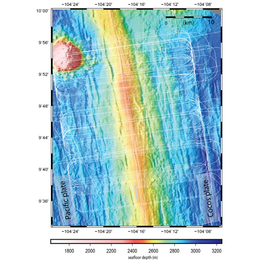
East Pacific Rise. More than 1000 km2 of 3D MCS data were collected for this project across the East Pacific Rise (Figure 1) on R/V Langseth in summer 2008. This was the first 3D MCS experiment carried out on an academic ship and using a multisource and multi-streamer system, and the first such experiment over a mid-ocean ridge. The main goals are to 1) provide the first geometrically correct, complete and detailed images of a mid-ocean ridge magma plumbing system and to 2) understand how the imaged magmatic system is coupled to corresponding volcanic, hydrothermal and biological systems.
Orphan Basin. This experiment was carried out in 2010 on R/V Explorer and resulted in a dense 500-km-long wide angle OBS profile across the Orphan Basin. One hundred OBS were deployed with spacing from 3 to 5 km. The goals of the project are to 1) form high-resolution traveltime tomography P-wave velocity sections and layered models, 2) use these models to improve our understanding of crustal thinning across the basin, and 3) test application of advanced imaging methodology on OBS data such as prestack depth migration and waveform tomography.
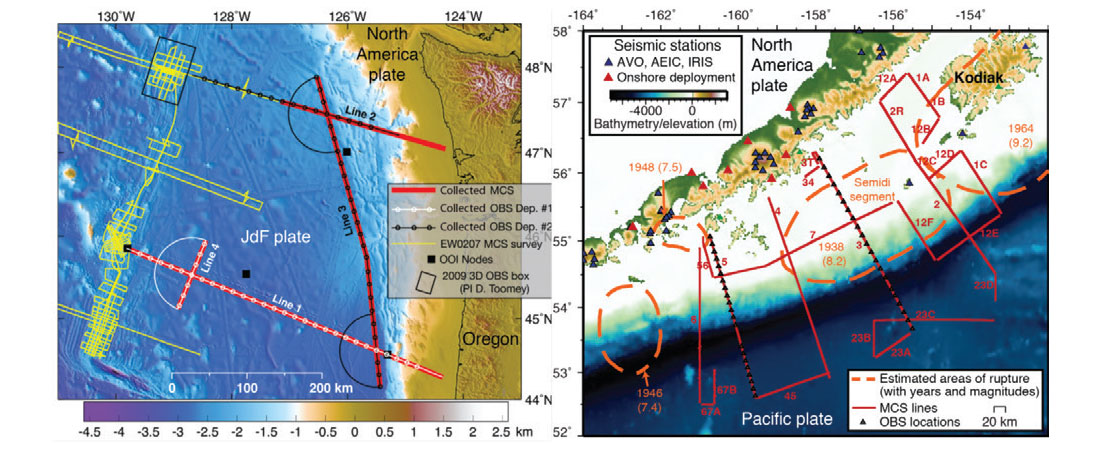
Alaska Subduction Zone. The 2011 Alaska program on R/V Langseth acquired ~3500 km of 2D MCS data and ~800 km of OBS profiles along the western Alaska subduction zone, from the freely slipping Shumagin gap to the locked region of the western Kodiak asperity (Figure 2, right). The profiles span the entire locked zone on the megathrust, including the updip and downdip transitions to stable sliding. The primary goal is to characterize variations in the geometry and properties of the megathrust and the downgoing plate and relate them to downdip and along-strike changes in slip behavior and seismogenesis.
Juan de Fuca Plate. This 2D MCS/OBS experiment to characterize the evolution of the crust and shallow mantle across complete transects of the Juan de Fuca (JdF) plate, from formation at the ridge, through alteration and hydration within the plate interior, to subduction at the Cascadia margin, was carried out in 2012 on R/V Langseth (Figure 2, left). The questions to address are: 1) How does the JdF plate evolve from ridge to trench? 2) What is the relationship between the state of hydration of the JdF plate at the Cascadia trench and the Cascadia subduction zone seismicity?
Offshore New Jersey. The 2014 R/V Langseth high-resolution 3D MCS reflection program (Figure 3) covering 500 km2 of offshore New Jersey is designed to tie clinoform geometry to facies successions and Neogene sea-level change. Objectives are to 1) establish the impact of known Ice House base-level changes on the stratigraphic record, 2) provide greater understanding of the response of nearshore environments to changes in elevation of global sea level, and 3) determine the amplitudes and timing of global sea-level changes during the mid- Cenozoic, which should help humanity put anthropogenic base-level change in a proper long-term context.
South-West Indian Ridge. This 2D and 3D MCS/OBS Fall 2014 program on R/V Marion Dufresne is designed to characterize the seismic properties of exhumed and partially serpentinized ultramafic mantle rocks across the ultra-slow spreading SW Indian Ridge. Questions targeted are: 1) How deep does serpentinization extend? 2) What is the proportion between serpentinized mantle and intrusive magmatic rocks within the crust?

Related Reading


Join the Conversation
Interested in starting, or contributing to a conversation about an article or issue of the RECORDER? Join our CSEG LinkedIn Group.
Share This Article