Geophysics @ Queen’s
Alexander Braun, P.Geoph.
Geophysical research and education at Queen’s University in the Department of Geological Sciences and Geological Engineering has a legacy of inspiring some of the most influential leaders in the natural resources sector and academia. The most notable geophysical research group in the past conducted work on exploration seismology. Geophysics related research, specifically geotechnical and geomatics engineering, has a strong record at Queen’s and is currently conducted by Dr. Jean Hutchinson, Dr. Georgia Fotopoulos, Dr. Mark Diederichs, and Rob Harrap.
In July 2013, the department appointed Dr. Alexander Braun, P.Geoph. as the new Applied Geophysics professor. At present, Queen’s offers undergraduate level courses in 2nd, 3rd, and 4th year as well as graduate education opportunities in Applied Geophysics. This is complemented by the annual Geophysical Field School conducted through a collaboration with The University of Western Ontario.
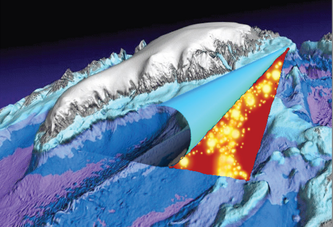
Today, geophysical research at Queen’s has two major objectives, i) to give students the opportunity to conduct applied research to solve societal problems, and ii) to employ geophysics for the development of integrated geosciences and geoengineering analyses. We emphasize the integration of diverse data and knowledge to create solutions for complex geoscience targets. Specifically, research in potential field geophysics (gravity and magnetics), satellite geophysics (altimetry, synthetic aperture radar, gravimetry), and Earth system monitoring (crustal deformation, glaciers and sea ice, sea/lake level change) is currently conducted (Figure 1). This is supported by the recently upgraded computing infrastructure (High Performance Computing Linux cluster), a large software donation by Landmark/Halliburton and in-house geophysical equipment funded by departmental alumni. With a broad spectrum of research projects, ranging from magnetic mapping of Amerindian settlements in Antigua (Figure 2) to global sea level change, we will focus on two projects herein, which are the most relevant to CSEG members.
In the past, the use of “Superconducting gravimeters” was limited to a few geodetic observatories worldwide. This changed with the development of the iGrav® field operable instrument a few years ago by GWR Instruments, Inc. It is a relative gravimeter with a sensitivity of approximately 0.1 microGal or 1 nm/s2. The application of such instruments for exploration geophysics was hindered by the fact that it integrates over all mass changes during a survey, including atmospheric pressure changes, tides, hydrological processes etc. Often, the signal is hidden in the environmental noise. This limitation can be overcome by measuring the vertical gravity gradient by using two instruments deployed at the surface. Our latest simulation of a fracturing experiment of a 2.5 km deep reservoir, revealed that the gravity signal at the surface is 20-30 microGal, which is clearly detectable by two instruments, despite the small fracturing induced density change in the reservoir of 0.05 g/cm3. We propose to apply this methodology to monitor fluid migration in diverse reservoirs including groundwater pumping, waste water injection and fracturing experiments. This approach has obvious synergies with microseismic monitoring and allows for improved monitoring of fluid migration patterns. Partners for this project include GWR Instruments Inc., ESG Solutions and Integrated Sustainability Consultants.

“Synthetic Aperture Radar (SAR)” from satellites provides images with spatial resolutions of up to 0.24 meter and as such supersedes the current resolution of optical imagery. In addition, the ability of SAR to extract quantitative information such as surface deformation, flow velocity and elevations makes SAR a logical tool for monitoring the ever changing Earth’s surface. We have used SAR to monitor glacial melting and land cover change and currently conduct research on rockslides and are monitoring Beaver activity in Canada by combining satellite altimetry, SAR and terrestrial and airborne LiDAR. Partners include RockSense GeoSolutions Inc. In a separate collaborative project with Environment Canada and the National Research Council - Institute of Applied Physics (CNR-IFAC), Italy, we conduct research on multi-frequency polarimetric SAR to monitor soil moisture in agricultural regions of Italy and Canada.
Further information on Geophysics@ Queen’s can be obtained from Dr. Alexander Braun, Department of Geological Sciences and Geological Engineering, 36 Union St, Kingston, ON, K7L 3N6, p: 613-533-6621 e: braun@queensu.ca.

Related Reading


Join the Conversation
Interested in starting, or contributing to a conversation about an article or issue of the RECORDER? Join our CSEG LinkedIn Group.
Share This Article