Geophysical Research at the University of Manitoba, Department of Geological Sciences
The geophysics research group at the University of Manitoba consists of three faculty members: Dr. Ian Ferguson (Professor), Dr. Andrew Frederiksen (Associate Professor), and Dr. Wooil Moon (Professor Emeritus), along with one technician and a variable number of graduate students (four as of July, 2014).
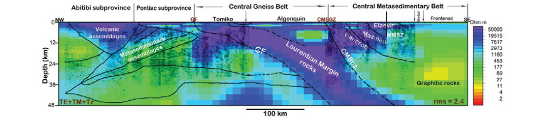
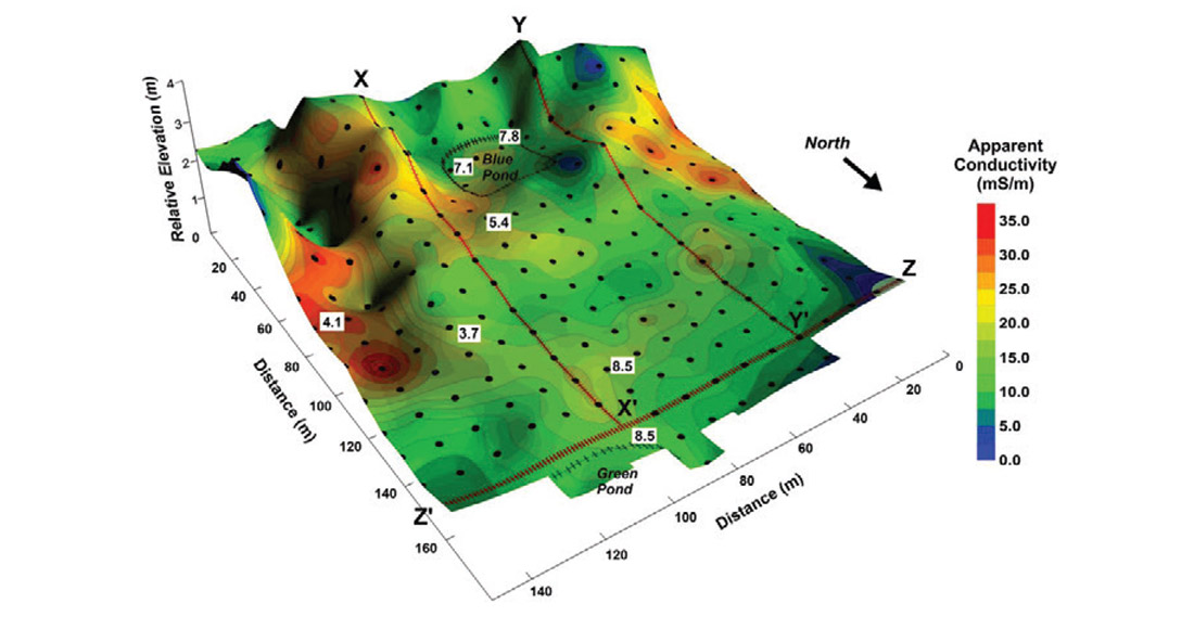
The research of Ian Ferguson and students in the electromagnetic geophysics group includes magnetotelluric (MT) imaging and tectonic interpretation of Precambrian continental lithosphere; examination of the effects of Earth resistivity on electrical power transmission; and application of electromagnetic (EM) methods in near-surface environmental and groundwater studies. The MT studies focus on Precambrian terrains in Canada and Australia, and have included studies of the Trans Hudson Orogen; Grenville Province; Western Superior province; Slave craton, Wopmay orogen and Canadian Cordillera; and Yilgarn craton and Fraser orogen in Australia. In the most recent study Ferguson and students have imaged the crust and lithospheric mantle beneath the Grenville Province in southern Ontario (Figure 1). The primary objective of the recent work in power transmission studies has been examination of the control of geological structures on ground potential rise of HVDC electrodes, e.g., the effect of the anisotropy in layered rocks in sedimentary basins. Previous near-surface studies of the electromagnetic geophysics group have included mapping paleochannel aquifers in southwestern Manitoba; delineating saltwater contamination in oil-fields in southwestern Manitoba; investigating shallow fracturing and groundwater in Precambrian shield rocks; monitoring freezing of soil; and delineating thickness and pore-water salinity of mine tailings (Figure 2). He is presently working on projects involving EM monitoring of CO2 sequestration at the Aquistore site in Saskatchewan and delineating permafrost at an anthropological site in the Canadian Arctic.
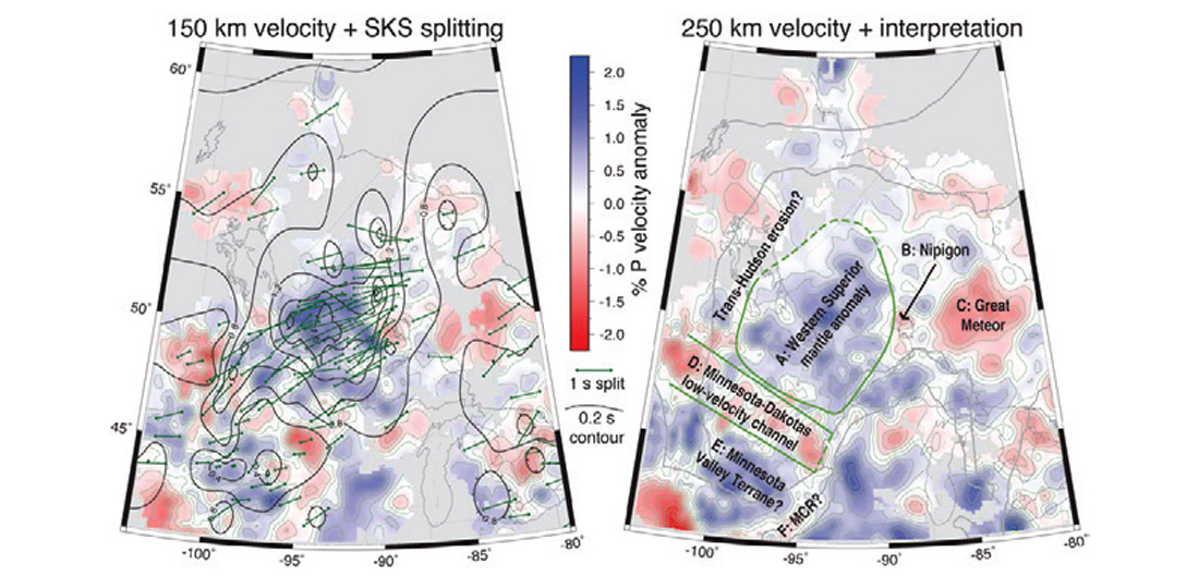
Andrew Frederiksen is a specialist in earthquake seismology, working on determining the structure of continental lithosphere from recordings of earthquake data, and so contributing to understanding the tectonic history of the Canadian Shield and the differing dynamics of the crustal and lithospheric processes involved. Figure 3 shows an example of his ongoing work in central Canada and adjacent areas of the United States, using two teleseismic methods (teleseismic tomography, which is sensitive to temperature and bulk composition, and shear-wave splitting, which is sensitive to mantle fabric) to map domains within the lithosphere of the Canadian shield, which are then related to tectonic and convective events over the past 2.6 Ga (Superior accretion, the Trans-Hudson orogeny, extension along the Mid-Continent Rift, and the influence of the Great Meteor hotspot). Continuing work on this area is being done as part of the international/multi-institution SPREE (Superior Province Rifting Earthscope Experiment, Stein et al., 2011) project, in which instrumentation was installed along the Mid-Continent Rift axis in both Canada and the USA from 2011-2013. Dr. Frederiksen is also currently developing improved techniques for extracting structural information from teleseismic data, such as a newly-developed method for independently measuring crustal thickness, sedimentary basin thickness, and crustal P/S velocity ratio from teleseismic P waves.
Wooil Moon is retired, but remains an active researcher in the areas of satellite geophysics and remote sensing.
Contact information
Department of Geological Sciences
University of Manitoba
125 Dysart Road, Winnipeg, MB, R3T 2N2
I. Ferguson: IJ.Ferguson@umanitoba.ca, 204-474-9164
A.W. Frederiksen: Andrew.Frederiksen@umanitoba.ca, 204-474-9460
W. Moon: Wooil.Moon@umanitoba.ca, 204-474-9833

Related Reading


Join the Conversation
Interested in starting, or contributing to a conversation about an article or issue of the RECORDER? Join our CSEG LinkedIn Group.
Share This Article