Geophysics at the University of Victoria
Geophysical research at the School of Earth and Ocean Sciences, University of Victoria (UVic), is carried out by faculty, students, and an active group of adjunct faculty (many at the Pacific Geoscience Centre of the Geological Survey of Canada, PGC/GSC). Research topics are diverse, but many focus on various aspects of earthquake seismology/ hazard analysis, relevant topics given UVic’s location just landward of the Cascadia subduction zone, the most seismically active region in Canada. Several representative research programs are briefly described in this article.
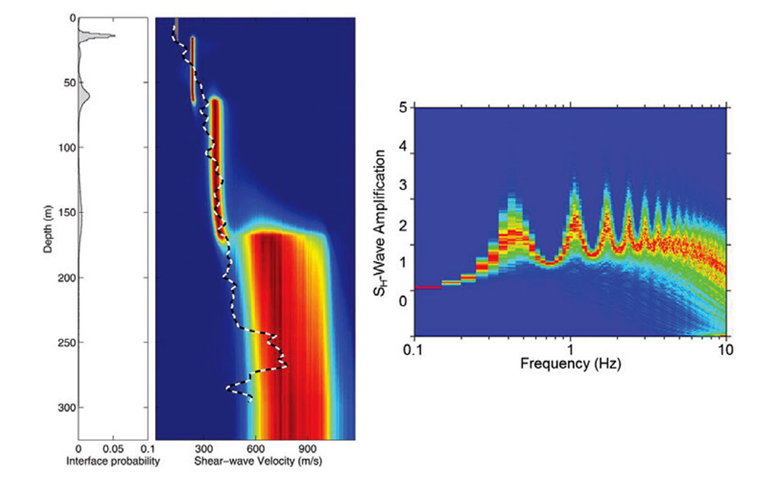
Geophysical Inversion: Inverse problems are ubiquitous in geophysics: A signal interacts with the earth such that observations of the signal (data) contain information regarding earth properties which are not directly accessible but can be inferred via inversion. The process is described by a model specifying the physical theory, earth system parameterization, and error statistics. Subjective assumptions on the model are often made in inversions and can have profound effects on parameter estimates and uncertainties; a more objective approach is to treat the model itself as unknown in the inversion. Professor Stan Dosso, Adjunct Jan Dettmer and their students are developing nonlinear inference methods for unknown parameterizations and error statistics via trans-dimensional (trans-D) Bayesian inversion which samples probabilistically over the number of system parameters (e.g., earth layers) and parameters of an autoregressive error model (Dettmer et al., 2012; Steininger et al., 2013). Trans-D inversion favours simple models consistent with data resolution (Bayesian parsimony), avoids linearization errors and subjective regularizations, and includes the uncertainty of the model in parameter uncertainty estimates. Figure 1 gives an example of the shear-wave velocity profile estimated via trans-D inversion of ambient seismic-noise dispersion measured on the Fraser-River Delta in Greater Vancouver, together with the resonance-amplification spectrum for earthquake-generated SH-waves predicted for this profile (in both plots colour scales represent estimated probabilities/uncertainties). Other inversion applications include teleseismic receiver functions, finite-fault rupture models, controlled-source electromagnetic measurements, and seabed acoustic reflection, scattering, and reverberation data.
Subduction Geodynamics: Adjunct Professor Kelin Wang (PGC/GSC) and his students are studying the geodynamics of subduction zones, especially processes related to the generation of large earthquakes and tsunamis. Their research addresses deformation cycles of great subduction earthquakes, the mechanics of subduction faults, and the thermal structure of the subduction system including mantle wedge flow and metamorphic petrology. They develop numerical models to study fundamental physical processes and use geodetic, seismological, heat flow, and other geophysical and geological data as constraints. This research has important implications to understanding seismic and tsunami hazards in western Canada and worldwide.
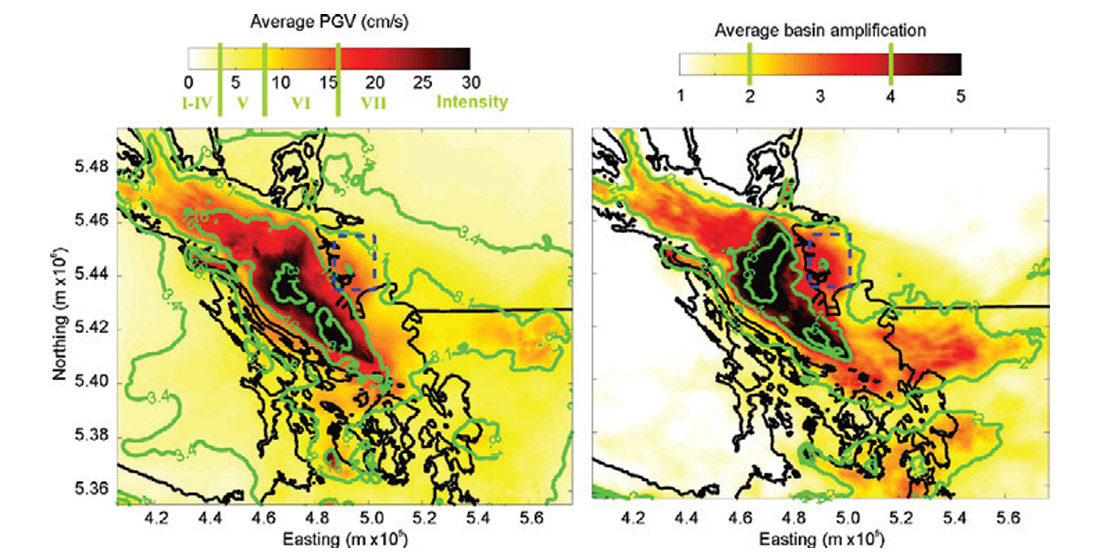
Earthquake Hazard Analysis: Adjunct Professor John Cassidy (PGC/ GSC) and his students are involved in all aspects of earthquake hazard analysis and mapping earth structure using passive-source seismology. Current research activities include time-varying earthquake hazard assessment (changes in the stress field caused by large earthquakes and linkages with aftershocks and fault-zone loading); mapping earthquake ruptures, including slip distribution and rupture directivity; understanding the variation in earthquake shaking (effects of soft soil, sedimentary basins, and topography); and structural mapping for hazard assessment and improved understanding of resource potential. A recent example of an important contribution highlighted by the Bulletin of the Seismological Society of America is a pair of studies that examine the effects of sedimentary basin structure on earthquake ground shaking across Greater Vancouver (Molnar et al., 2014a, 2014b). Numerical modelling with realistic deep and shallow earthquake sources show that ground shaking could be amplified by factors of 4-5 and the duration of shaking extended by 10-20 s for sites located on the basin compared to sites away from the basin (see Figure 2). These results will contribute to improvements in earthquake building codes in the region.
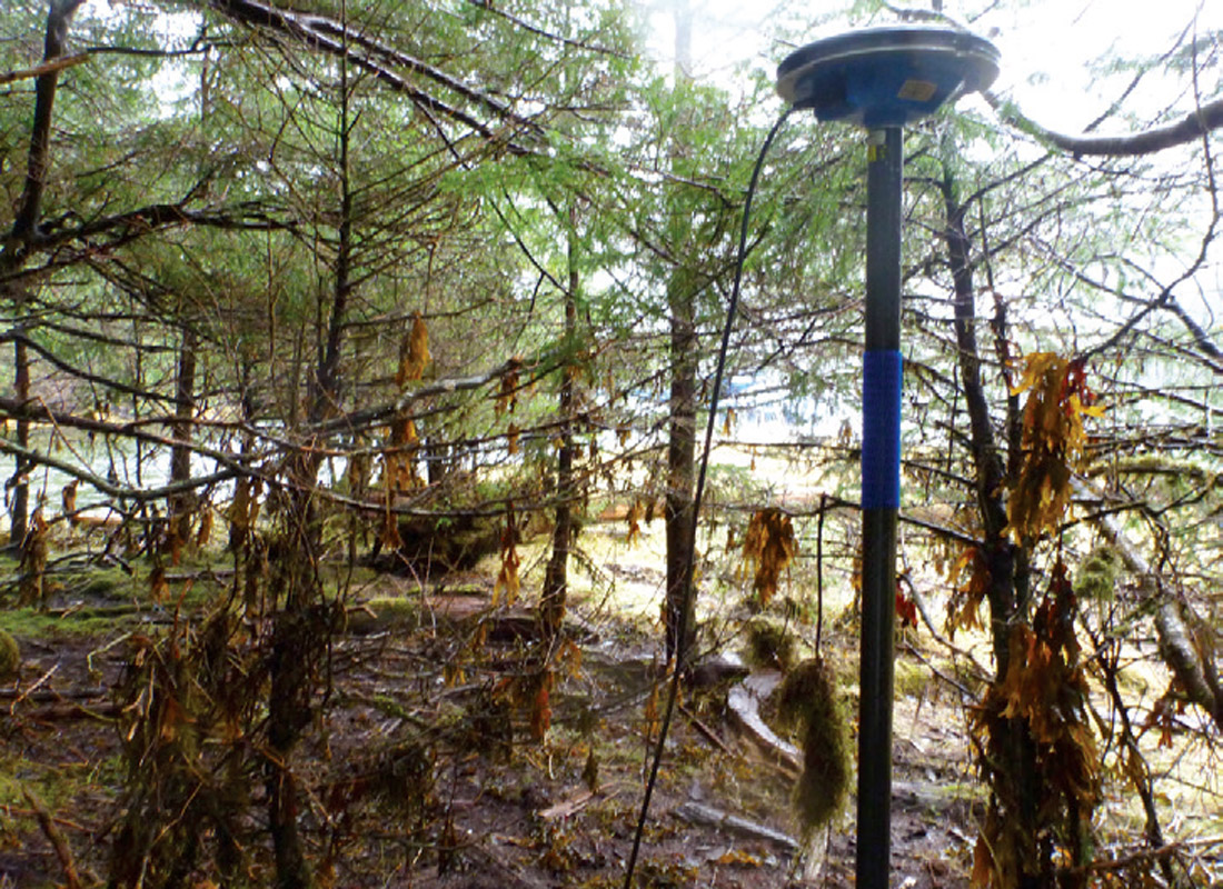
Tsunami Hazard Assessment: Assistant Professor Lucinda Leonard’s main research interests concern the current tectonics of western Canada and adjacent areas. She uses GPS, seismicity, and other geophysical data to analyze crustal deformation and to assess the seismic and tsunami hazard of plate boundary and crustal faults. Recent work includes a preliminary tsunami hazard assessment of Canada (Leonard et al., 2014), and field studies of the 2012 Haida Gwaii tsunami (see Figure 3; Leonard and Bednarski, 2014). The tsunami reached up to 13 m above the state of tide on the west coast of Haida Gwaii, making it the largest tsunami of the year, globally. The tsunami was generated by thrust faulting during the second largest earthquake (magnitude 7.8) ever recorded in Canada, in a region where previous large earthquakes involved strike-slip faulting.

Related Reading


Join the Conversation
Interested in starting, or contributing to a conversation about an article or issue of the RECORDER? Join our CSEG LinkedIn Group.
Share This Article