Introduction
The application of geophysical methods for near-surface studies related to environmental monitoring has increased significantly over the past few years. Knowledge of an industrial site is now required prior to plant construction, as well as for site remediation when industrial plants are dismantled. In particular, the presence of contaminants in the subsurface poses one of the greatest concerns since these liquids may be hazardous to public health.
Of all of the geophysical methods available, the reflection seismic technique is probably the least applicable for environmental assessment programs because of the very shallow depths (< 10 m) involved, the band-limited nature of the data, and the overwhelming presence of shot-generated noise at the very short traveltimes involved. Electrical, electromagnetic, magnetic and refraction seismic methods have traditionally provided the most useful data for shallow studies. Recently, ground penetrating radar (GPR) has become an additional tool for such programs.
In this paper, we present some results of a ground penetrating radar survey at the former Canada Creosote site in Calgary. The objectives of the program were to evaluate GPR in a variety of near-surface conditions and determine the applicability of the method for mapping subsurface creosote contamination at this site. Creosote is a wood preservative derived from coal tar and may be denser than water when mixed with other organic compounds.
Site description
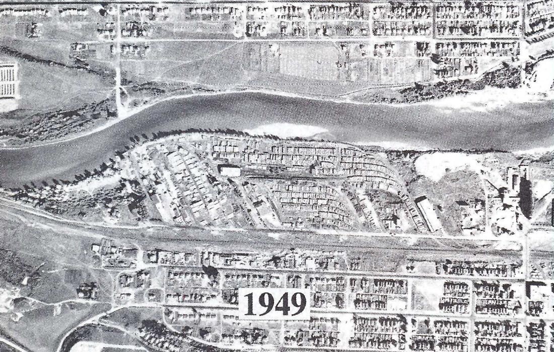
The former Canada Creosote site is located on the south bank of the Bow River, just west of downtown Calgary. It is bounded approximately by 14th Street on its eastern side, Crowchild Trail to the west, 9th Avenue on its southern side and the Bow River to the north (Figure 1). Between 1924 and 1962 a creosote wood treatment facility operated at the site, initially by the Alberta Wood Preserving Company and later by the Canada Creosote Company. Figure 2 shows activity at the site in 1949. The creosote treatment facility is visible in the central part of the site, which in terms of present geography (Figure 1) is immediately east of a car dealership (Renfrew Chrysler), located north of Bow Trail.
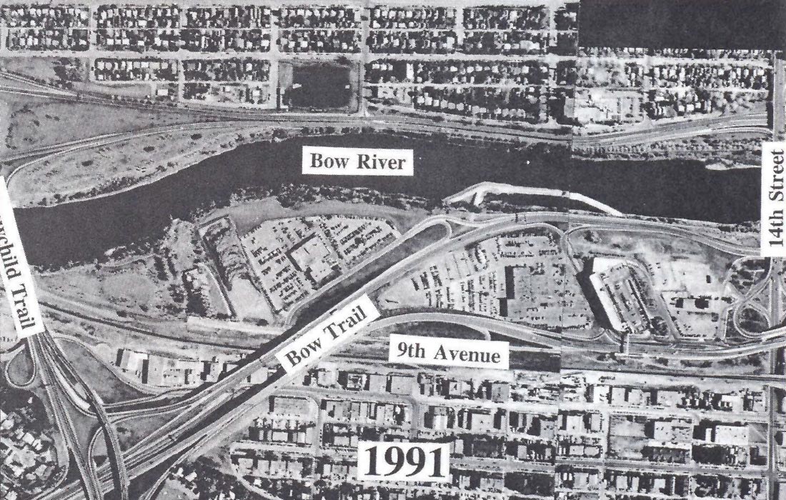
In 1988, Alberta Environment began an investigation of the site and found creosote contamination below the water table in several boreholes. Late in 1989, creosote was found to be seeping into the Bow River near the site and a berm was constructed to prevent further discharge of creosote into the river. This berm is visible in Figure 1. Subsequent studies by Alberta Environment indicated that up to 4,000 m3 of creosote might underlie the site within an area between the former treatment facility and the present berm in the Bow River. Additional drilling programs on the north bank of the river in 1992 showed creosote contamination within bedrock fractures near Memorial Drive and 19th Street. It is thought by Alberta Environment that these contaminants are sourced from the Canada Creosote site and have migrated within bedrock below the river.
GPR survey and results
The GPR method is well-described in the geophysical literature. It operates by transmitting a pulse of high frequency electromagnetic energy into the ground and recording reflections of this energy from interfaces across which there is a contrast in dielectric constant. The propagation velocity and attenuation of this energy depends mainly on the dielectric constant and electrical conductivity, respectively, of the host medium. Velocities in earth materials are generally between 0.1 and 0.5 of the velocity of light (0.3 m/ns) and tend to decrease with water content. Attenuation is severe in conductive rocks.

Several GPR profiles were established at the Canada Creosote site, as shown in Figure 3. Where possible, these profiles were located to tie with drillholes in order to provide control for interpretation of the GPR data. Lines were located at river level as well as on the floodplains and over fill material away from the river banks in order to test the depth of penetration of the GPR signal in different geological settings. GPR data were collected in a single-channel mode using a PulseEKKO™ IV system operating with 50 MHz antennae. A trace separation of 1 m and an antennae separation of 2 m was maintained for all lines collected. Data processing consisted of trace scaling with a 50 ns window length and filtering with a passband between 25 MHz and 100 MHz. Processing was carried out on a personal computer using VISTA™ 6.5 processing software. In order to use this package, a time scaling factor of 103 was applied to the data prior to processing. A subset of the data acquired are shown here to illustrate the results.
Figure 4 shows data collected from along Line 1, located near Bow Trail (Figure 3). This line is situated on fill consisting of clay and debris overlying fluvial sands and gravels. These sediments are underlain by sandstones and shales of the Paskapoo Formation which is of Tertiary age. Line 1 crossed two drillholes and the geological data from these holes have been plotted on the interpreted section assuming a constant velocity of 0.09 m/ns; creosote was intersected below the water table in the northern drillhole. However, the GPR data show no interpretable events at the base of the fill, the water table or bedrock. Also, the low frequency content of the data indicates that severe attenuation of the radar signal above 30 MHz has occurred. Similar data were collected along Lines 2 and 6 (Figure 3), both of which were also located on the floodplain about 4 m above present river level.

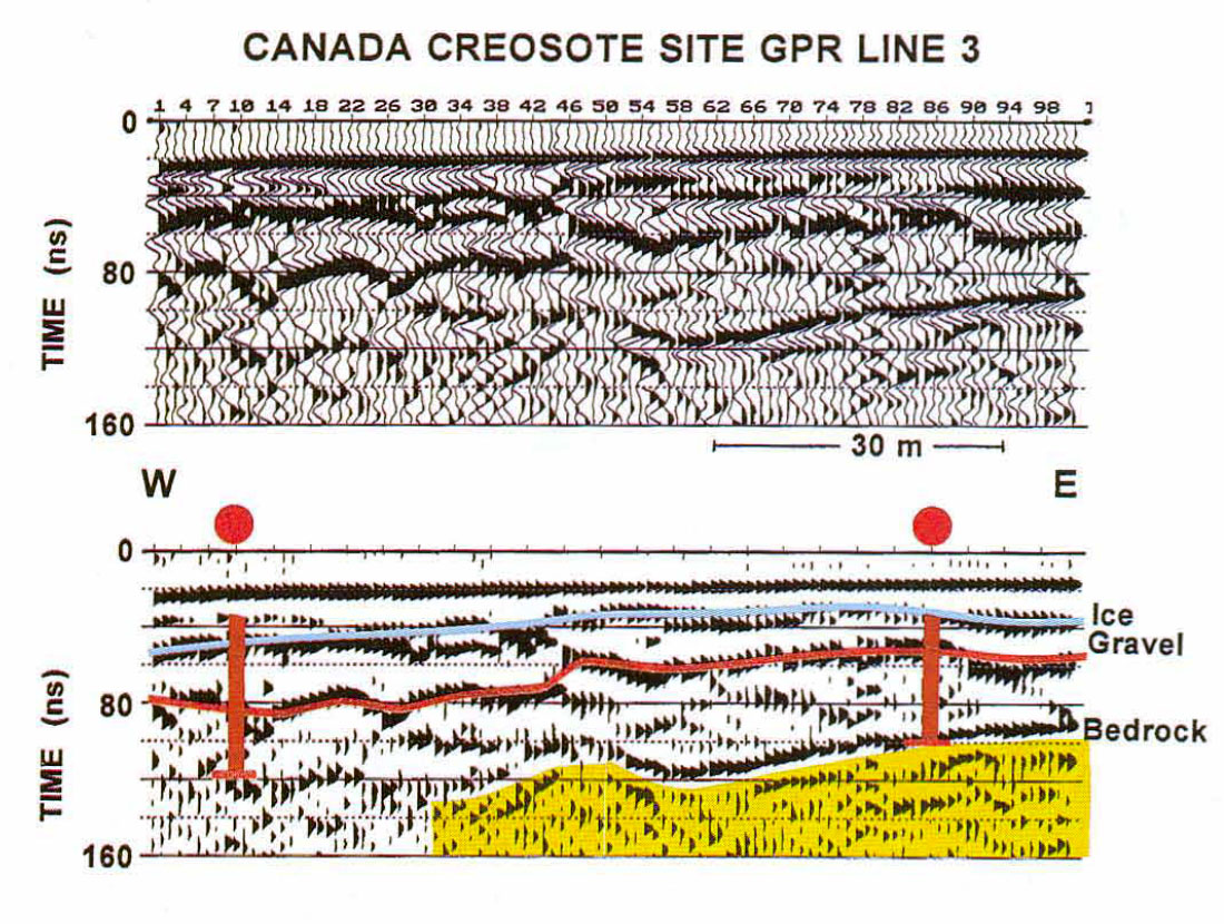
GPR data collected on outcropping gravels and sands at river level were found to contain better reflections than the floodplain lines. Figure 5 shows processed and interpreted data from Line 3, which was located within the berm (Figure 3). These particular data were collected during winter and there was a thick layer of ice (up to 1 m thick) above the river bottom in this area. The events interpreted in the section are base of ice, top of the gravel sequence, and bedrock. Depths at the boreholes were corrected for the ice layer assuming an ice velocity of 0.16 m/ns and good agreement with bedrock depth was obtained at the east end of the line. The bedrock is interpreted to deepen toward the west, with some local topography near the centre of the line; a bedrock event could not be interpreted at the west end of this line.
Good data were also obtained along Line 4 which is located at river level along the south of the Bow River, west of the berm (Figure 3). Processed and interpreted data from this line are shown in Figure 6. The bedrock is interpreted to be rather shallow in this area and shows local depth variations of up to a metre below river gravels. Later events may indicate bedding within bedrock although the signal is rather reverbatory. Diffractions from two storm water drains locally contaminate the data at the positions indicated on the section.

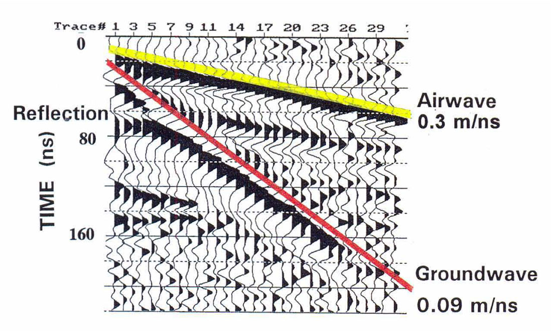
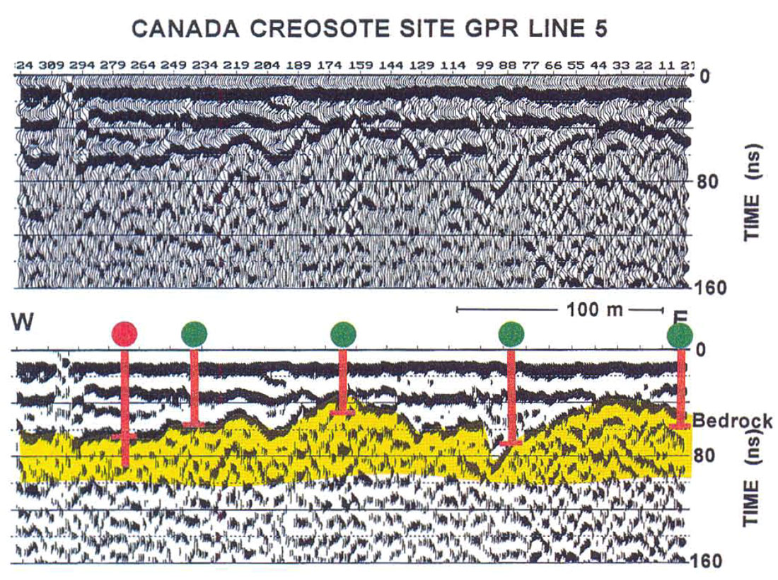
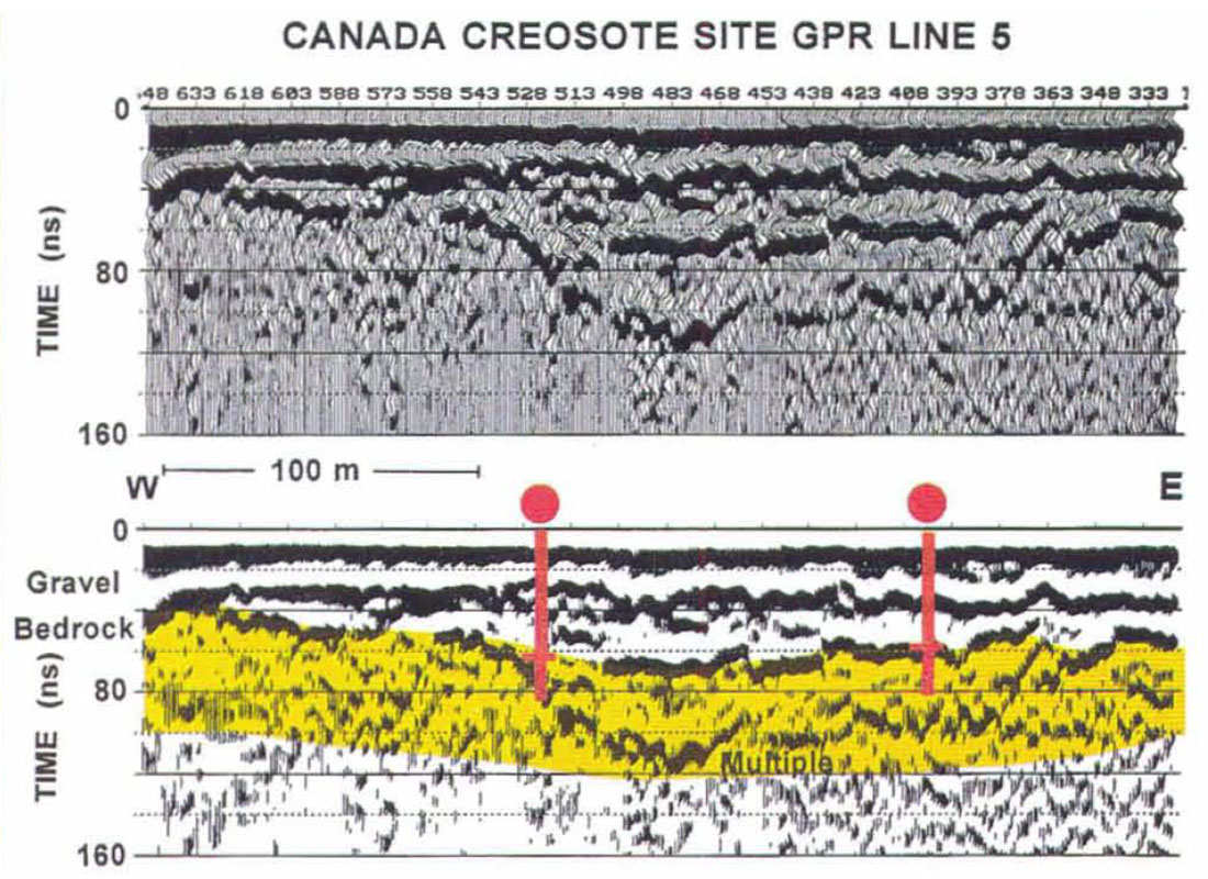
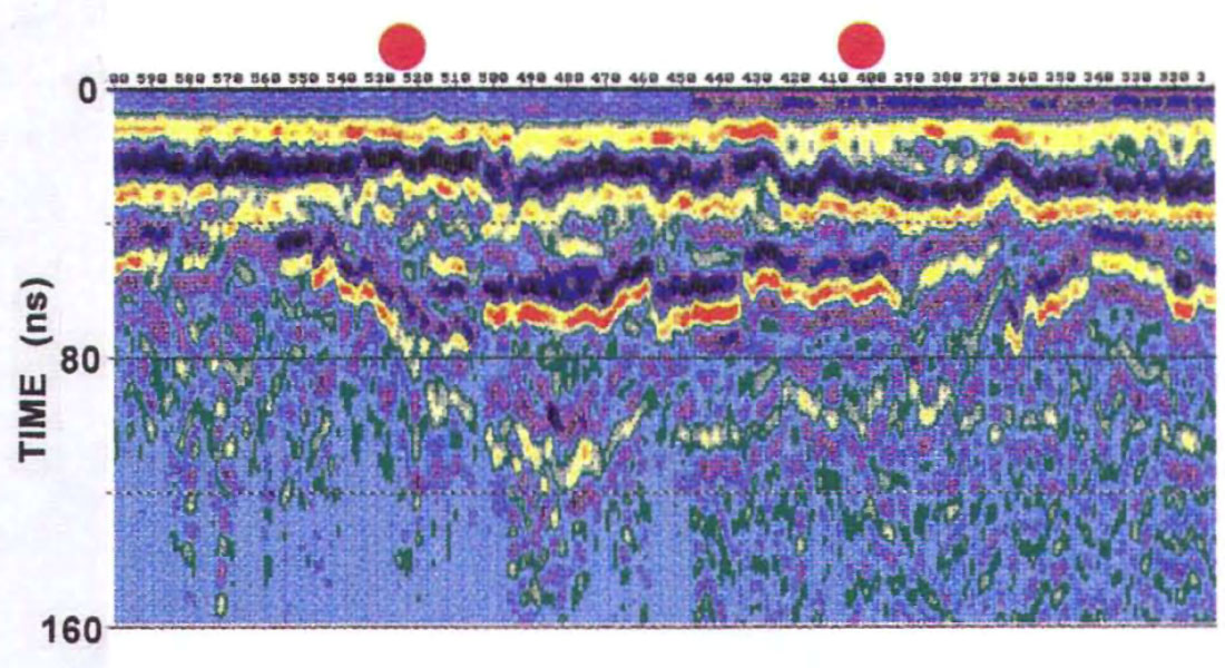
On the north side of the river, a CMP gather was acquired near the area in which drillholes along Memorial Drive encountered creosote in bedrock fractures (Figure 3). This CMP gather is shown in Figure 7 and shows a clear reflection, at about 70 ns at near offset, which is asymptotic to the direct groundwave. The groundwave velocity was found to be 0.09 m/ns and this value was used for depth to time conversion for control drillhole data along or projected into Line 5. This line is over 600 m long and occupied the north bank of the Bow River between 16th and 19th streets. Processed and interpreted data from Line 5 are shown in Figures 8 and 9, the line being divided into east and west halves. A clear bedrock reflection is identified along all of Line 5 and interpreted depths agree reasonably well with those from drillholes. Differences may be due to lateral changes in velocity along the line or because some of the drillholes are offset by several metres from the line. From east to west, the bedrock profile shows a local depression at SP 88, a gentle ridge at SP 170 and then a broad, shallow low between SP's 250 and 550. A bedrock multiple is visible between SP's 370 and 530. Of particular interest is an amplitude anomaly in the bedrock event in the vicinity of the drillholes which found creosote contamination in bedrock fractures. Figure 10 shows a variable colour density plot of this part of Line 5, showing the amplitude anomaly at about 70 ns. The cause of the anomaly may be increased bedrock reflectivity due to a decrease in dielectric constant of the bedrock as a result of creosote displacing water in fractures.
Discussion
This research program has shown that GPR is a viable technique for investigating near-surface sediments in an active fluvial environment. Within and beside the Bow River, reflections from bedrock were obtained from depths of up to 5m. On the north bank of the river, a zone of increased amplitude of the bedrock reflection coincides with an area of creosote contamination in bedrock fractures. In contrast, on floodplain deposits beside the river, GPR yielded very poor data and severe signal attenuation occurred due to the presence of conductive clay, silt and fill material which overlies the river gravels.
The present status of the Canada Creosote site is that various remediation plans are being studied by Alberta Environmental Protection, with the favoured option being a containment wall along the southern bank of the Bow River. No remedial action is planned for the north side of the river because bedrock depths are in excess of 6 m.

Acknowledgements
Data collection was assisted by Malcolm Bertram and Eric Gallant. Drillhole data and other information about the site were provided by Alan Hingston of Alberta Environmental Protection and through technical reports by Golder Associates of Calgary.


Join the Conversation
Interested in starting, or contributing to a conversation about an article or issue of the RECORDER? Join our CSEG LinkedIn Group.
Share This Article