Is it the right time to invest in electromagnetic techniques? This question is being asked from a wide range of perspectives:
- From an exploration geophysicist’s perspective will EM help reduce risk on a target that has some ambiguous seismic characteristics?
- For a chief geoscientist, the question might be; “Is it the right time to hire a geophysicist with EM experience rather than rely on consultants and contractors?”
- The business manager of a major seismic company might ask; “Are there any EM companies left out there for me to buy so I can offer that service?”
- From a government regulators perspective; “Should we consider EM to be equivalent to seismic in assessing work commitments and resource calculations?”
A “high risk” answer is yes, a “risk averse” response is no, and a safe answer is to wait and see what happens over the next few years as the EM business stabilizes. Electromagnetic methods; I include the full frequency spectrum from DC resistivity (0 Hz), through CSEM (0.1 Hz – 100 kHz), to Ground Penetrating Radar (10-1000 MHz), have been around for many years. They are the geophysical methods of choice for the mineral exploration and environmental geophysicist because they generate anomalies that are at the resolution appropriate to the cost of drilling a well. The popularity of EM in the oil exploration business has cycled up and down over the last 75 years. The recent upward cycle is unprecedented in terms of money being spent on development and surveys. There have been many review articles written in the last few years about the genesis of the current marine controlled- source EM methods (e.g. Constable 2005, Edwards 2005), and anyone attending the last three SEG meetings will have witnessed the standing-room-only sessions on electromagnetics.
In the last 6 months many of the major companies involved in EM have been bought by, or aligned themselves with, large seismic companies. Given the popularity of the marine EM methods it seems like good business for a major geophysical company to buy a small EM company to offer that service to its existing client base. A similar trend occurred in the mid-1980’s when a series of small EM companies (e.g. Phoenix, Geoterrex, and Zonge) were traded back and forth between some of the larger full-service geophysical corporations (e.g. World Geoscience, and Compagnie Générale de Géophysique).
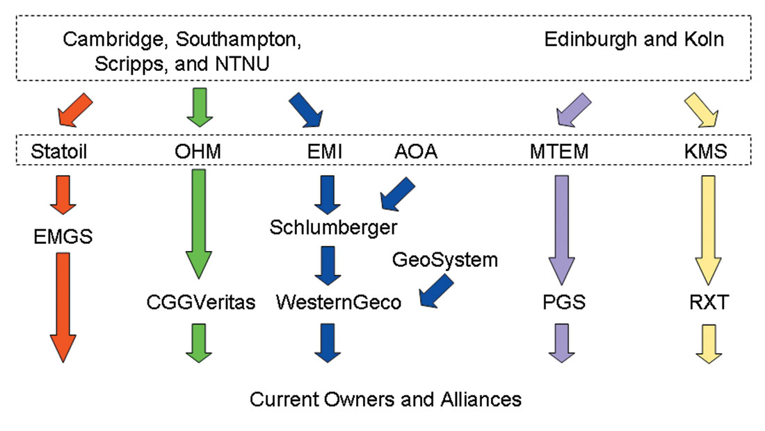
Figure 1 shows the current pattern of company purchases and alliances. The figure is an overview of the academic origin of the EM systems, and the path they took to major commercial surveys. The figure does not include the input from oil companies that supported the development through consortia.
Are there companies around that are still “independent”? There are several companies that have a history of innovative developments in EM methods and continue to work independently (e.g. Phoenix Geophysics, Quantec Geosciences, Zonge Engineering, and Lamontagne Geophysics). With the exception of Phoenix Geophysics, these companies have not had a great deal of exposure to the oil and gas industry. On the flip side, there is one major geophysical company (Fugro) that dominates the world of airborne electromagnetics and marine geotechnical surveys, yet has not made any obvious move into the world of marine EM for exploration. There is certainly room for a few more players on the EM field.
A few words of caution. Seismic and EM are very different geophysical services. Seismic and EM methods have different resolutions. They can be complicated, highly 3- dimensional data sets, contaminated with both cultural and geological noise. The data are collected in very different ways. Seismic (2D or 3D) comes in a fairly well understood set of geometries:
- Source: dynamite, vibroseis, or airgun.
- Receiver: geophone, hydrophone, or accelerometer.
- Deployment: land cables, nodes, marine streamer, OBS, or OBC.
In contrast the range of EM geometries is daunting even to the experienced geophysicist:
- Source: electric or magnetic dipole with vertical or horizontal orientation.
- Receiver: electric or magnetic receiver in 3 orientations.
- Signal: Time or frequency domain.
- Deployment: Towed transmitter and receiver, one stationary, or both stationary.
In my opinion, the current trend of EM services being driven by seismic companies is going to produce a lot of client and shareholder expectations that cannot be met. On the other hand, the exposure of the EM methods to the hardware and processing power of the seismic industry is going to accelerate the developments in acquisition and processing . However, I predict that we will see a few of the EM groups being spun back out of the seismic companies when it becomes obvious that you can’t market EM using the same business model as seismic. Taking a few lessons from the mining and environmental industry, my other predictions are as follows:
- Petrophysical developments will improve our understanding of the relations between seismically derived rock properties (Vp, Vs, λ, ρ, μ, φ) and electrically derived rock properties (σ, φ, and pore distribution).
- There will be more of a focus on deriving velocity and density from seismic, as joint or constrained inversions of seismic and non-seismic (EM and gravity) methods appear.
- The EM contractors will offer borehole-to-borehole and borehole-to-surface EM tomography, to improve the vertical resolution of surface EM methods.
In closing, I would like to offer my list of recommendations for geophysicists considering EM for exploration:
- Do the forward modeling (2D or 3D) to decide on the resolution needed, versus the resolution possible.
- In general, the vertical resolution is 5 -10% of the depth of investigation, and getting 3 layers out of an unconstrained inversion is pretty good, so… keep it simple!
- Put the project out to competitive bid to get several options for contractors.
- Use an independent client representative on the survey to make sure you get good quality results.
- Request and archive copies of the raw data because the new developments will come in noise reduction , processing, and inversion.
No matter whether you look at the EM business from a commercial perspective or a technical angle the present trends in EM are different from the surge in popularity in the mid-1980’s, and I think EM will be on the scene for a while.


Join the Conversation
Interested in starting, or contributing to a conversation about an article or issue of the RECORDER? Join our CSEG LinkedIn Group.
Share This Article