Canada belongs to an elite club of a handful of countries that successfully developed and used autonomous ocean-bottom seismometers (OBSs). Yet, with the decommissioning of the Canadian short period OBS pool in 2015 due to old age and retirement of researchers with OBS knowledge, Canada was on the verge of losing this hard-earned expertise gained over almost half a century. This development coincided with an increasing awareness and recent consensus across Canada regarding: (1) the key importance of Canada’s offshore to Canadians; (2) the lack of the knowledge needed about Canada’s offshore to fully benefit from it; (3) the essential need to work together at all levels, from local to international, to effectively explore the vast Canadian offshore. Seizing the opportunity, a team of seismologists from ten major Canadian universities formed a partnership and obtained funding to develop a National Facility for Seismic Imaging (NFSI) housed at Dalhousie University. At the core of the NFSI will be a pool of 120 state-of-the-art broadband OBS instruments, which will ensure continuity of marine seismological research in Canada and much beyond. The NFSI is expected to become a leading world-class facility enabling unparalleled imaging and monitoring of critically important structures in the Earth, thus providing a foundation for transformative research at Canadian universities. This should position Canadian scientists at the forefront of future discoveries and encourage collaborations in large-scale international offshore Earth science experiments. The multi-user nature of this facility is aimed at forging, fostering and supporting a wide spectrum of collaborative experiments previously not possible, with goals that will range from fundamental scientific discovery to applications with specific relevance to Canadian societal issues. The NFSI will become fully operational by 2021. The planned research projects are designed to benefit Canadians through scientific outcomes with an impact on determining marine geohazards facing Canada, supporting resource exploration and exploitation, and development of Canada’s Arctic region.
History of the OBS development
The ocean-bottom seismometer (OBS) is a seafloor instrument designed to record seismic waves generated from both man-made and natural sources. Motivation for the development and use of OBS instrumentation is multifaceted. About 71 percent of the Earth's surface is covered by water, making complete and detailed investigations of the whole Earth structure unattainable with only land stations because the information about the Earth’s interior that recorded waves carry is limited. Most of the plate boundaries (e.g. subduction zones, ridges, transform fault zones) and other 1st-order structures (e.g., continentocean transition zones) that form as part of the Earth's plate tectonic cycle, as well as other structures important to understanding mantle dynamics like hot spots, are located in oceanic regions and can only be studied by instrumenting the seafloor. The lithosphere, Earth’s solid outer layer, has a different structure and composition beneath the oceans and continents, and the oceanic lithosphere cannot be probed comprehensively without placing instruments on the seafloor to record the waves with propagation confined entirely to oceanic structures. Lowering the magnitude threshold to detect smaller, local submarine earthquakes and determining their focal mechanisms requires dense local networks of recording stations. Such seafloor networks also result in a globally more uniform spatial distribution of seismological stations positively impacting identification and characterization of distant sources and Earth’s large-scale structures. The ability to discriminate between single force and double couple sources improves the effectiveness of worldwide monitoring of large explosions and makes it possible to distinguish between tectonogenic and rock-slide-generated earthquakes.
The first seismographs were laid on the seafloor by US researchers in 1937 and 1938 at depths exceeding 2000 m during several attempts to shoot seismic refraction profiles [Ewing and Vine, 1938]. These early OBSs were not autonomous instruments. Instead, sources and receivers, distributed along a 1 km long electrical cable, were lowered to the seafloor on one end of a steel wire [Ewing, et al., 1946]. Only one of these tests, about 350 km south of Newport, Rhode Island, resulted in useful data [Ewing and Ewing, 1961].
A new system was already developed in 1939 and 1940, one that started to incorporate some of the characteristic features of modern OBS instrumentation. OBSs and seismic sources were equipped with timers, dropped to the bottom separately, and operated autonomously. After the tests were completed, the ballast on the OBSs and seismic sources detached automatically, allowing them to float to the surface. A small amount of seismic refraction data was obtained at two stations: south of Cape Cod, Massachusetts and northwest of Bermuda in water as deep as 4800 m [Ewing et al., 1946].
World War II interrupted further development of OBS instrumentation in the USA, with the work resuming only in 1951 [Ewing and Press, 1952], but at slow speed due to limited financial support [Ewing and Ewing, 1961]. By 1960 new OBS designs allowed advances like data telemetering to the ship, data recording on magnetic tapes, and battery life sufficient to record for up to a week [Ewing and Ewing, 1961]. However, longer recording times and seismic sources near the sea surface were needed to investigate regional-scale structures with sufficient data density. By early 1960s, with the development of a reliable autonomous OBS instrument at the Lamont-Doherty Earth Observatory of Columbia University and its testing in deep water offshore California [Sutton et al., 1965], it became possible to routinely carry out large wide-angle surveys.
Japan, the Soviet Union, and the United Kingdom developed OBS instruments during the 1960’s with Canada, France and Germany joining the OBS development club in the 1970s [e.g., Nagumo et al., 1965; Witmarsh, 1970; Hussong, 1972; Kasahara et al., 1974; http://www.science.gc.ca/eic/ site/063.nsf/eng/97308.html]. During these two decades, the number of academic institutions in the USA involved in OBS development expanded to include the University of Hawaii, the University of Washington, Massachusetts Institute of Technology, Scripps Institution of Oceanography, and Woods Hole Oceanographic Institution [Johnson et al., 1977; Sutton et al., 1977; Koelsch and Purdy, 1979; Duschenes et al., 1981]. All the developed OBSs included short-period (SP) sensors (1-4.5 Hz natural frequency), hence the name SPOBS, and analogue data recorders. Many of the SPOBS designs were only single component (1-C) instruments having a vertical geophone or a hydrophone. However, some SPOBS designs were 4-C (one vertical and two horizontal geophones, and one hydrophone) and had the sensor package deployed separately from the instrument platform directly on the seafloor for improved coupling. The recording time on the seafloor was extended, but was still limited to about a couple of months.
The 1980s were characterized by a technological leap from analogue to digital technology and, in the late 1980s, the beginning of the development of broadband OBS instruments (BBOBS) [Suetsugu and Shiobara, 2014]. Rapidly improving digital technology at the end of the 20th and the beginning of the 21st century allowed for, among other things, large dynamic range of recording of up to 24-bit. Major improvements have been made in several complementary directions: (i) power consumption, data storage and battery energy density, allowing deployments with continuous recordings of more than one year, (ii) design of both reliable leveling mechanisms and release systems, allowing high recovery rates (>99 per cent), and (iii) seismometer design, permitting the deployment of true broad-band sensors (e.g. <0.01 Hz to >100 Hz flat response) to the ocean floor. The availability of BBOBSs that can record for extended periods of time significantly broadened the scope of scientific objectives that can be targeted in marine environments to include, for example, from characterization of seismicity and structure to improving constraints on both remote dynamic triggering of earthquakes and locally induced low-level microseismicity. However, the exciting new science made possible with the early BBOBSs came with a cost, as these instruments tended to be very large and expensive to operate.
Development and use of the Canadian OBS
The Atlantic Geoscience Centre at the Bedford Institute of Oceanography (BIO) in Halifax, Nova Scotia, was the focus of early OBS development in Canada that started in 1975 with a purchase of two instruments designed and built at the Hawaii Institute of Geophysics [Heffler and Barrett, 1979]. The purchased instruments were critical in providing an impetus for the effort to gain experience with OBS instrumentation, which did not exist in Canada at that time. When more OBSs were required for research, the original Hawaii Institute of Geophysics system design [Sutton et al., 1977] was modified to improve performance of the newly built OBS. This process started in 1976 with an addition of a vacuum chamber release mechanism, followed by improvements to the frame and electronic control system [Heffler and Locke, 1977]. The release system was changed several years later to a more reliable burn-wire mechanism, also designed in-house [Heffler, 1984].
With the design and construction of a prototype digital data recorder in the mid-1980s, the centre of OBS development shifted toward Dalhousie University under the direction of Dr. Keith Louden. This instrument advanced the existing analog OBS previously developed at BIO. Further development took place in the early 1990s with the design and construction of six fully digital 4-C (3 orthogonal ground motion components plus hydrophone) instruments. This work was funded primarily by NSERC with some additional support from DREA, now Defense Research and Development Canada (DRDC) – Atlantic. Improvements to the design and production of additional instruments continued in the late 1990’s with additional NSERC funding through the MARIPROBE Program [Louden, 2002] and a subsequent Research Tools and Instruments grant in the mid-2000s.
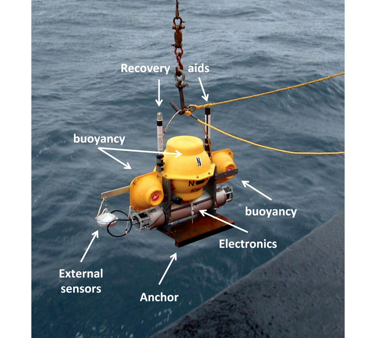
A pool of more than 20 of these instruments was operated through a Dalhousie University (Dal) – Geological Survey of Canada (GSC) – Atlantic collaboration until 2015, when they were decommissioned due to advanced age. The Dal/GSC OBS represented the only such capability in Canada. As shown in Figure 1, these OBSs consisted of an instrument package inside an aluminum pressure case attached to a steel anchor. Glass floats provided buoyancy. Surface locating devices included a strobe light and radio beacon. The OBS was deployed individually, after which it sunk to the seafloor, deployed a separate low profile 3-component geophone module directly on the seafloor, and recorded seismic data continuously for up to several weeks following a preset starting time. The OBS were retrieved by acoustic command that released the 82 kg instrument package and flotation from its 55 kg anchor. The OBS was 1.1 m tall, 1.2 m long, and 0.6 m wide. Maximum depth of deployment was 6000 m.
Extensive use has been made of these instruments in Canada, with over 555 deployments over the past 25 years in collaboration with users at Dal, the GSC, Memorial University, the University of Victoria, and the University of British Columbia. These uses include deep crustal studies in eastern [Louden, 2002] and western [Zelt et al., 2001] Canada, studies of gas hydrates in shallow sediments of the Vancouver [Schlesinger et al., 2012] and Scotian [LeBlanc et al., 2007] margins, studies of right whale sounds in the Bay of Fundy [Laurinolli and Hay, 2004], and a recent microseismicity study off Haida Gwaii, British Columbia [James et al., 2013]. The instruments have also been used in collaboration with other research and industry groups world-wide, including gas hydrate studies in the Gulf of Mexico [Jaiswal et al., 2006], deep crustal studies in the Iberia abyssal plain [Chian et al., 1999], in the Los Angeles basin [ten Brink et al., 2000], off West Africa [Contrucci et al., 2004], and in the Labrador Sea [Delescluse et al., 2015], Orphan Basin [Lau et al., 2015; Watremez et al., 2015], the eastern Mediterranean [Welford et al., 2014], and southwest Indian Ocean [Leroy et al., 2015].
National Facility for Seismic Imaging
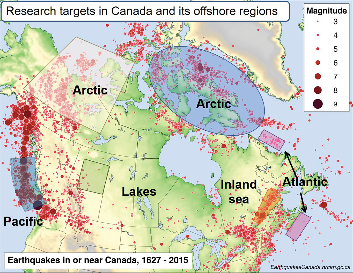
Canada has by far the longest shoreline in the world and unrivalled access to the bordering oceans, where the exclusive economic zones stretch for 370 km offshore. The Atlantic, Pacific and Arctic Oceans are of key importance not only to Canada’s economy, but also to Canada’s environment, culture, public health, and society. Scientific study of the offshore region provides the basis for understanding and managing ocean and seabed resources and natural hazards. Yet Canada lacks capacity in many areas of marine work. For example, Figure 2 shows that much of the seismic risk to Canadians and Canadian infrastructure stems from offshore areas where by far the largest majority of the earthquakes are generated. Oceans Networks Canada has recently mounted an important effort to instrument the area offshore southern Vancouver Island with BBOBSs. However, the area covered represents a small fraction of the Canadian offshore, and the infrastructure is not mobile but instead fixed to a cabled observatory. In order to protect all Canadians, it is essential to develop a comprehensive national strategy in marine seismology, to enhance collaboration at the local, regional, national, and international levels, and to facilitate the sharing of infrastructure and knowledge [Expert Panel on Canadian Ocean Science, 2013].
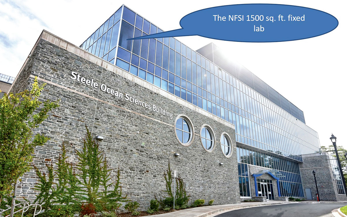
Directly addressing these needs, Dal, in partnership with nine other universities from across Canada (UVic, UBC, SFU, UofM, UofT, uOttawa, UQAM, McGill and Memorial), proposed, and in 2017-2018 obtained, funding from the Canadian Foundation for Innovation (CFI) and six provincial matching funds agencies to establish a National Facility for Seismic Imaging (NFSI). The NFSI will consist of (i) 120 compact, versatile, next-generation BBOBSs; (ii) a portable lab, deployment and storage facility suitable for global marine operations; and (iii) a fixed BBOBS laboratory (Figures 3) that will support the pan-Canadian and international instrumentation, data preprocessing, and storage needs. The future use of these seafloor-based seismic recording systems is expected to result in a broad range of innovative research investigations across the world’s oceans and inland seas that were previously not possible, and to enable unparalleled imaging and monitoring of critically important structures in the earth. This, in turn, is expected to result in a leap forward in offshore geoscience in Canada, and to position Canadian scientists at the forefront of future geoscience discoveries, and Canada as a global leader in the field.
A fully mobile BBOBS facility with the 120 instruments will provide multi-dimensional benefits. For controlled source seismic surveys, in addition to being able to acquire longer profiles or cover larger areas, it will be possible to deploy dense receiver arrays and apply advanced data analysis techniques such as full-waveform inversion and prestack depth migration. These methods provide far greater detail about targeted subsurface structures than do standard methods such as travel time tomography or layered modeling. A similar leap forward will be possible for passive source seismic studies by computing earthquake locations and velocity/image sections and volumes using, for example, ambient noise tomography, double-difference, source spectra, moment tensor inversion, receiver functions, scattered-wave imaging, time-reversal, surface-wave analysis and teleseismic body-wave tomography methods.
To ensure effective and sustainable use of the infrastructure over the expected operational lifetime of the instruments of 15-20 years, the NFSI will serve academic, government, and industry multi-user, multi-disciplinary research communities, often in multi-institutional collaborative research programs. The planned reliable, rugged, light, and small instruments will minimize the cost of the field experiments with a large number of BBOBSs carried out in remote and hostile environments. These instruments will be stackable in standard 40-foot containers for shipping, and will be easily deployed and retrieved at sea from smaller-sized, lower-cost vessels available in the proximity of the proposed study areas. Housing and maintaining the infrastructure at Dal will provide significant additional cost efficiencies by minimizing the maintenance, mobilization, demobilization, and operating costs, and by fostering sharing and collaboration at both national and international levels.
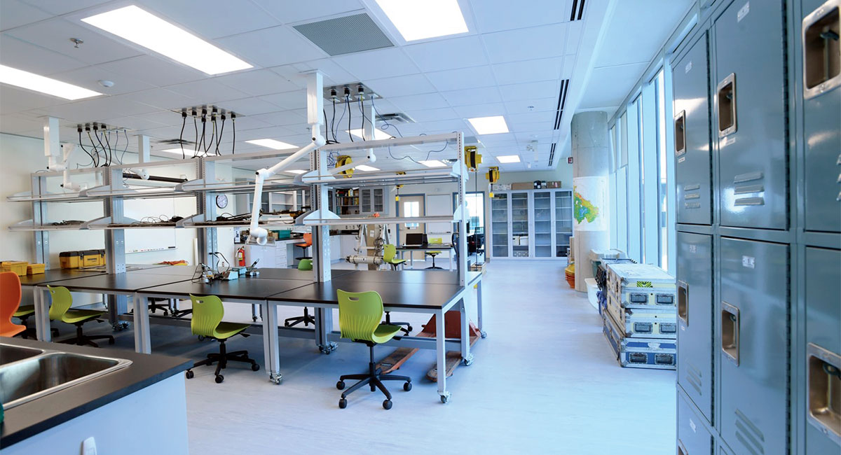
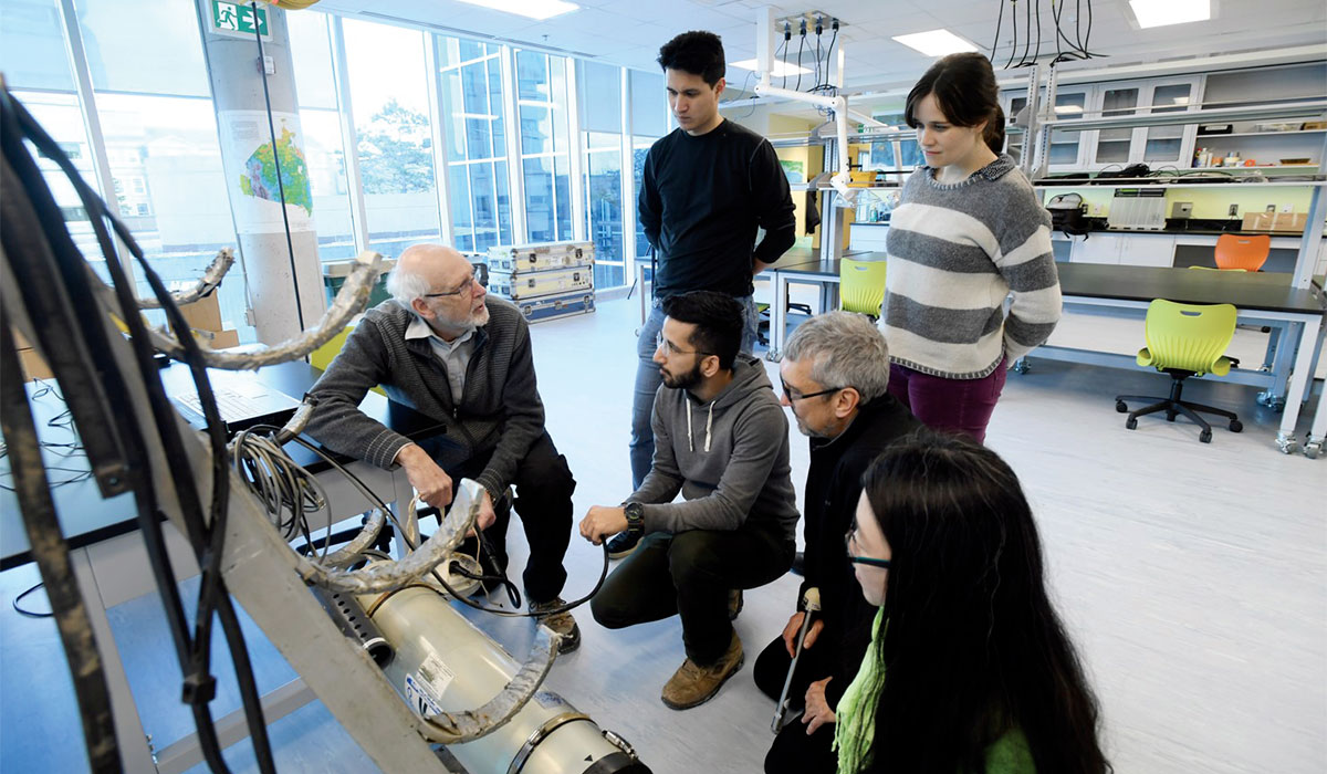
Development of the fixed BBOBS laboratory in the Steele Ocean Sciences Building at Dal (Figures 4 and 5) has been completed. Tests of the prototype instruments are expected in late fall of 2019 or spring of 2020, with the full 120 BBOBS pool and facility test taking place about a year after. Normal operations of the NFSI will start once the full facility test is completed. A web-accessible database that will host all future BBOBS data is under construction with the existing OBS and academic multichannel seismic (MCS) data from offshore Atlantic Canada currently being deposited to prevent their loss and to test the database design and functionality.
Future research using the NFSI pool of 120 BBOBS
The research proposed to CFI consists of four programs that are here, together with their goals and corresponding broader impacts, briefly summarized in single paragraphs.
The Arctic Ocean Program: the Arctic is of particular scientific and economic importance to Canada. Over the next few decades, the impact of accelerated melting of Arctic glaciers and sea ice will lead to further opening of the Arctic Ocean and increased seismicity. This will present significant policy and environmental challenges for Canada. It is essential that policy decisions related to resource exploration and other development in the Arctic be based on the best possible scientific knowledge. The proposed program consists of two projects focused on the Beaufort Sea region and Canada’s Arctic Archipelago, which aim to improve our understanding of earthquake processes, subsurface structures, and ice failures. The study areas cover large sections of Canada’s Arctic, including the region that marks the eastern entrance to the Northwest Passage, which is of strategic significance for Canadian sovereignty.
The Pacific Ocean Program includes two projects. The first targets major seismic hazards on Canada’s west coast, where a diverse range of faults endanger up to 3 million people and industrial infrastructure along the B.C. coast. The source of much of the risk stems from the plate boundary faults that reside offshore, away from the existing land-based seismic network stations. The proposed studies are crucial to assessing seismic hazard and can only be achieved through large BBOBS deployments. The second is an international effort to study seismic hazards offshore Chile, site of the largest earthquake ever recorded, the magnitude 9.5 1960 event, which generated a devastating tsunami that affected many Pacific Rim nations.
The Atlantic Ocean Program investigates the transition from magmatic to amagmatic rifting offshore south-central Nova Scotia and central Labrador – a key and unresolved issue in the evolution of continental margins. The proposed study areas are the only places along the entire eastern North America margin where this type of transition occurs. From an economic perspective, the proposed program also covers areas of recent hydrocarbon exploration, and the results will provide information complementary to that obtained by industry investigations, thus further reducing the geologic risks associated with exploration.
The Inland Seas and Lakes Program’s key goal is to improve constraints on both (i) locally induced low-level microseismicity in the Canadian Prairies and Central Canada and (ii) dynamic triggering of seismicity in the St. Lawrence Channel by large remote earthquakes. Anthropogenically induced earthquakes due to industrial activities in the Canadian Prairies, Central Canada, and elsewhere where active hydraulic stimulations spatially coincide with critically important infrastructure such as dams are of growing concern for both industry and government agencies in Canada. These earthquakes are a recent phenomenon, are quickly becoming a public safety issue, and will undoubtedly trigger critical shifts in provincial and national environmental policies and regulations in the near future. The resulting scientific information will provide a basis for these new policy decisions and regulations.
Delivering on the research proposed to CFI will be challenging. The CFI funding decisions are largely driven by the proposed research, but the funding is given only for the infrastructure, and there currently is no clear mechanism or program in Canada to apply to for funding for the kind of research proposed. The NSERC Ship Time Program provides one million dollars annually for ship time that is distributed over a number of research projects in all scientific disciplines. However, single world-class surveys, like the ones briefly presented here, usually cost more than the annual NSERC Ship Time budget. The NSERC Special Research Opportunity (SRO) program represented the kind of mechanism needed in Canada to productively operate cutting-edge facilities like the NFSI but it was cancelled in 2009. Despite these challenges, the NFSI co-PIs and other users are putting significant effort into raising research funding through other sources, including international, and have had some success. Grants and in-kind support have already been obtained through MEOPAR (Marine Environmental Observation Prediction and Response) Network of Centres of Excellence, GSC, and the US National Science Foundation to deploy the BBOBSs in summer 2020/2021 in two of the most earthquake-prone areas of Canada, the Baffin Bay and the Queen Charlotte Fault. However, until the need for better integration between Canadian infrastructure and research granting agencies is addressed, Canadian leadership in high-profile international projects will remain particularly challenging.
Conclusions
Canada is shaped by the ocean and has by far the longest shoreline in the world but, relative to most other maritime nations, Canadians derive disproportionally little wealth from the ocean system, as much of our vast offshore remains largely unexplored and underused. To directly address the need for greater understanding of our offshore, a team of seismologists from ten research-intensive Canadian universities formed a partnership and obtained funding to develop a National Facility for Seismic Imaging (NFSI) at Dalhousie University. The NFSI will consist of 120 next-generation BBOBSs, a portable lab, deployment and storage facility, and a fixed BBOBS laboratory that will support the pan-Canadian and international needs. The future use of this fully mobile BBOBS facility with 120 compact and versatile seafloor-based seismic recording systems will provide multi-dimensional benefits. The NFSI is expected to become a leading world-class facility enabling unparalleled imaging and monitoring of critically important structures in the Earth, thus providing a foundation for transformative research at Canadian universities and positioning Canadian scientists at the forefront of future discoveries. The multi-user nature of this facility is aimed at forging, fostering and supporting a wide spectrum of collaborative experiments previously not possible, with goals that will range from fundamental scientific discovery to applications with specific relevance to Canadian societal issues. Canadians are expected to benefit through scientific outcomes with an impact on: (i) determining marine geohazards facing Canada, such as those from earthquakes, tsunamis, submarine slides and catastrophic ice failures; (ii) supporting resource exploration by providing a regional geologic framework to aid in site selection of detailed industry surveys; (iii) evaluating the risks related to resource exploitation by characterizing induced seismicity; and (iv) development of Canada’s Arctic region with implications for national defence.

Acknowledgements
For generous, long-term, and ongoing support, MRN is grateful to his NFSI co-PIs (Dr. Pascal Audet at UOttawa, Dr. Michael Bostock at UBC, Dr. Andy Calvert at SFU, Dr. Fiona Darbyshire at UQAM, Dr. Stan Dosso at UVic, Dr. Andrew Frederiksen at UofM, Dr. Qinya Liu at UofT, Dr. Yajing Liu at McGill, Dr. Kim Welford at Memorial), Dr. Keith Louden – the central figure to the Canadian OBS development and the current NFSI Facility Manager, Dr. David Simpson – the Chair of the NFSI Advisory Council, and numerous administrators and personnel at Dalhousie University. Additional thanks goes to the dozens of potential future NFSI users from various academic, government, and industry groups around the globe, many of whom provided letters of support at the NFSI proposal stage (e.g., Ecole Normale Supérieure – France, GEOMAR – Germany, Ocean Networks Canada – British Columbia, Centre for Earth Observation Science – Manitoba, Canada-Nova Scotia Offshore Petroleum Board – Nova Scotia), Department of Energy – Nova Scotia, Offshore Energy Research Association of Nova Scotia – Nova Scotia).


Join the Conversation
Interested in starting, or contributing to a conversation about an article or issue of the RECORDER? Join our CSEG LinkedIn Group.
Share This Article