
Between Christmas and New Year’s of 2018, Rob Stewart, Jean Legault, and Oliver Kuhn met at Dr. Gordon West’s midtown Toronto condo to interview the retired University of Toronto professor. Dr. West is one of Canada’s most prominent and accomplished hard rock geophysicists. Working under J. Tuzo Wilson early on as a student, Dr. West became well known in his own right over a long and productive career. He is still an active member of the geophysical community, interacting with both industry and academia. Thousands of geophysicists around the world are familiar from their student days with the famous textbook he co-authored with Fraser Grant, Interpretation Theory in Applied Geophysics. For decades he ran the Applied Geophysics group at the University of Toronto, supervising numerous graduate students, including Rob Stewart. His application of a broad range of geophysical techniques to the study of the Canadian Shield greatly advanced this field. Gordon and Yves Lamontagne collaborated extensively, and together are considered critical to the development of modern EM (electromagnetic) techniques. The following is an abridged version of the interview conducted with Dr. West…
OK: Gordon, where did you grow up, and what attracted you to geophysics?
GW: I was born in Toronto and am very much a hometown boy. I love to travel and see the rest of the world, but I'm quite attached to Toronto and Ontario. My father was an architect and did quite well in the ‘20s but had a terrible time in the Depression. He was still operating an office at the end of the war, but just barely. Being an architect, he believed that if you're going to be in a profession, it's important that you meet people and have some connections, so he was quite keen to send me to private school, to Upper Canada College. While I wasn't really that type of boy, it was a good school.
The big thing right after the war was radio, so I was a radio nut. I built all kinds of radio apparatus and had my own amateur radio station. I had a really tremendous Physics teacher at UCC, Mr. Colton. It became obvious that I should head into the engineering physics program at university.
RS: At UCC, was there an electronics class, or club?
GW: There was a club! The Radio Club.
RS: Is that what helped your interests develop or were you doing things more on your own?
GW: Well, both. We had a little room up in the old tower as a place to do projects. There were half a dozen other students in the club. It was great. After the war there was an enormous quantity of surplus electronics available for a song. Mr. Colton went off and bought 25 meters, so in our physics lab you could do electricity experiments, and everybody had a voltmeter and an ammeter.
RS: Would you say that this was fundamental and foundational for your development?
GW: Oh sure! – for my interest in instruments, and for my approach to science. We learned by building radios and reading things like the Radio Amateur’s Handbook and a fantastic engineering book called the Radiotron Designer's Handbook. With these, a bunch of components and a soldering iron, you could put things together. It was quite amazing what you could get into, and you learned from your mistakes – quickly if there was high voltage!
When I graduated, I didn't want to go into Electrical Engineering at university, so I applied to Engineering Physics. I should mention that I’d had two summer jobs – after High School graduation and after first year university – as an Electrical Draftsman, first at Comstock, a big company that did all the electrical work for the Toronto subway, then at the Toronto Board of Education electrical department. By the end of that, I knew I was not interested in being an electrical engineer.
My parents didn't have anything like a cottage, but they felt young people should get out of the city in the summer, so as a kid, I’d spend summers at camp, and loved it! That's where my connection to the Earth and geophysics came from. After two years of very heavy mathematics in Engineering Physics, which I found it a bit much, and the two summers of electrical drafting, I heard Tuzo Wilson describe geophysics – studying the Earth and travelling the world – and it was, "WOW, that's for me!" I took the geophysics option of Engineering Physics, and the decision was made.
RS: Was it called geophysics then?
GW: Yes. Geophysics at U of T actually goes back well before Tuzo Wilson. Professor Lachlan Gilchrist was involved in geophysics in the 1930s, and then during the wartime, there were two young Ph.D. scientists - Norman Keevil and Arthur Brant - do you know those names? Keevil founded Keevil Mining and brought the airborne magnetometer to Canada. Arthur Brant went to Newmont in Arizona, became their Chief of Research, and developed time domain IP before all others. Both are in mining halls of fame, so it's not a case of Wilson being the first notable geophysicist at U of T. But that era was broken up by the war.
RS: Where was the first geophysics course taught, when it was actually called geophysics? There's the Dominion Observatory in the early 1900s and the Geological Survey of Canada, but would U of T have been the first university in Canada to provide a course in geophysics?
GW: We have no record of Lachlan Gilchrist teaching a named geophysics course. However, Bill Scott has found a record of a pair of undergrad courses introduced in 1930 to provide a physics basis for geophysical methods. Gilchrist, who was a physics professor at that time, did employ Wilson as a summer student to go on some geophysics programs. But it goes back to even earlier times - the British Imperial Geological Survey, or a name like that. They instigated a test of geophysical methods in the 1930s. They had tests over various ore deposits in Canada, Australia, and probably South Africa too. Lachlan Gilchrist was involved in that, and so were the people at McGill. Ultimately the exploration geophysics that survived in Montreal was at the École Polytechnique, and I don't know its early history.
Larry Morley, who became the Chief Geophysicist at the Geological Survey of Canada, began undergrad studies in geophysics before the war, and then he returned at war end to complete his Ph.D. in rock magnetism. Prior to that, all geophysics was done at the Dominion Observatory.
JL: Right, the Morley-Vine-Matthews hypothesis regarding sea-floor spreading...he just passed away recently, didn't he?
GW: Yes, he did. He enrolled at U of T before the war, but left to join the navy, then came back to finish his Ph.D. in 1946. And Stan Ward, as a partner in Phoenix Geophysics, did a Ph.D. on early EM. Actually, with my background in amateur radio, I found his Ph.D. fascinating. He wanted to find the optimum EM frequency for sulphide deposit prospecting. In the Radio Amateur’s Handbook, he found plans for 500 W audio amplifiers that handled from 20 Hz up to 20 kHz, because that is what you needed to amplitude modulate a 1 kW radio frequency signal. They built one of these monsters - it was a huge rack-mounted thing full of Hammond transformers – and that was their source signal. They concluded that the best single frequency to use was 1000 Hz, which was what people had already started using.
Anyway, there was a long tradition of applied geophysics at U of T; it just wasn’t formally named Geophysics until later on.
JL: In that period from 1955 to when you graduated to 1960, you didn't go on directly to a Ph.D. did you?
GW: No, I intended to enter the geophysical prospecting industry, and it was easy to get summer work in those days. So, while I wasn't out in industry for very long, I had a lot of different summer jobs, in different areas. I got a little bit of experience here, a little bit there - I was very lucky.
JL: With many different companies?
GW: Mainly with mining companies, but I spent the summer of 1954 in Saskatchewan, with GSI, the precursor to Texas Instruments. We shot 2-mile seismic correlations, running around with one receiver spread, one shot at every second Section corner. We didn't have GPS levelling in those days, so a good part of the crew were land surveyors. They were busy running elevations, because every time we did a shot, there'd be two miles of levelling to be done!
OK: In Saskatchewan that would not involve a lot of levelling. (General laughter)
GW: You're quite right! But you couldn't just do it by sighting across two miles. We did that once or twice, but there was hell to pay because it wasn't accurate enough.
The previous summer I had worked for Eldorado (later Eldorado Nuclear), also in Saskatchewan, in the Foster Lakes area, where we were following up a helicopter radiometric survey, then later up at Beaverlodge that same summer. The comparison between the summer working for Eldorado and the summer working for GSI, plus my background in canoeing, that fixed me....mining geophysics was it!
JL: That's exactly what happened to me when I was a young man. I was going into Civil Engineering but fell in love with geophysics as a surveyor on a Northern Saskatchewan gravity crew. I loved nature, canoeing, the outdoors, I was a Boy Scout…that's exactly what got me into geophysics too.
GW: Next, in May of 1955, I got employment with Dominion Gulf, which was an offshoot of Gulf Oil’s R&D. They had created the airborne magnetometer during the Second World War. Keevil had encouraged them to survey in Canada, and actually Larry Morley had worked on that also...
JL: …yes, I spoke with Larry Morley at a KEGS Christmas function, and he described that to me. He convinced the Geological Survey to do regional airborne magnetic across Canada.
GW: That's right! They brought in a permanent crew and it became a little exploration company. It was part research and part regional exploration. It was a fabulous company to work for as a young geophysicist – we called it Gulf University. If we found an interesting feature, we’d immediately stake the ground, do blanket ground magnetics, drill some holes, and work on it until we figured it out.
I worked for them for a year and a half until they shut down, due to not making any money! It was a fabulous experience. During that time commercial airborne electromagnetic surveys with a towed bird system all began.
Norman Paterson was the Chief Geophysicist at Dominion Gulf and formally my boss. They shipped me all around. I worked at sites in Northern Ontario, Quebec – the Abitibi region, Chibougamau – then down to New Brunswick for a winter doing check surveys. An airborne survey had found some zinc deposit conductors. Airborne navigation back then was not solid, so we went in with ground EM, mag and gravity geophysics to check out the airborne EM features.
That was all great, but short-lived. I realised I'd been working with EM but didn’t really understand it, so I thought I’d get a Master's and figure out what it was all about. My Ph.D. was very mundane really. EM surveys were the in thing from 1958 through the early 60s, but we really had nothing to interpret the data with, so I made a bunch of scale models using big sheets of metal. My Ph.D. was just a systematic exploration of the response of thin conductive sheets of varying sizes at different depths and dips, then matching it to field data and showing it was relevant.
RS: So, the Master’s led to a Ph.D., but how did you get into teaching?
GW: There were a lot of students interested in applied geophysics, but Wilson's department didn't have an applied geophysicist anymore. Pat O’Brien had gone, and Norm Patterson had gone to Dominion Gulf. I was a grad student doing applied work, so I was sort of arm-twisted to teach some of the courses, especially the laboratory part, and I just gradually ended up doing it on a regular basis. I had intended to return to industry in 1960, but life got interesting. I had gone to Finland on a student exchange for the summer of 1959 to work with Outokumpu, a major Finnish base metal mining company. They had a pile of geophysical data around their big ore deposit near Joensuu in Eastern Finland to look at. I worked there and got to know some of the Finnish geophysicists...
OK: And the ladies!
GW: ...and the ladies! I met my wife Katri in Helsinki that summer. That clicked, and in late 1960 she came here. I was offered a junior lectureship at U of T to look after the applied geophysics program, and somehow it just flourished, step by step. For at least 10 years I expected it to end. Eventually, funding at universities changed. Until 1965, even later, it was very difficult to run a research program. You had to find independent outside financing for anything – there was no grant system. Suddenly, in the mid-60s, the National Research Council began a university research grants program. It became possible to teach and get funding for research projects. That changed my outlook.
OK: The possibility of doing research kept you there?
GW: Yes. But my bread and butter was still teaching applied geophysics.
OK: And I would imagine teaching that course produced the textbook?
GW: Yes.
JL: I really want to know more about how you embarked on writing a textbook.
GW: Foolishly! I would never have done that on my own. I will tell you how it happened, because it's an interesting piece of history. I was a useful hired hand for practical teaching but wasn't really thought of as "academic" by the physics department, which was a correct assessment from their point of view. They had identified another graduate who had gone off and done a Ph.D. at Cambridge - Fraser Grant. He was brought in as an Assistant Professor, and took over the lecturing that year, while I focussed on the lab courses.
Fraser found the teaching of some of the students difficult because of their inadequate math background, and he had some conversations with Prof. Willy Watson who was Chair of Physics. Grant complained that there was no decent textbook - just some old books like Jakosky, and Heiland...you've probably never even heard of them. Watson said, "You need a textbook? Well, sit down and write it!"
Fraser started on it himself, then realised what a colossal job it was, and also that he had very little practical experience and no familiarity with electromagnetics, so he talked me into joining the project. This was the summer of 1959, because I remember writing some of the chapters in Paris. I spent the 1960/61 academic year on leave on a post-doctoral fellowship at Thellier’s lab in Paris. He was a pioneer in rock magnetism and had done all kinds of early experiments on remnant thermo-magnetisation.
JL: When I was a student, I found your text unique. It had very detailed and methodical presentations of mathematical problems, yet there were examples of mineral exploration deposit responses.
GW: That was the idea, to relate classical mathematical physics theory to geophysics. Existing texts lacked reference points, and yet we needed a connection between theory and application. Fraser identified that need and was the great instigator. His style set the tone in the book, and that was very important.
OK: Sounds like a good combination.
GW: It was a great combination. He was an incredibly good writer. He would write several completed foolscap pages at a time, go through them and change two words, and that was it! Linguistically he was a Mozart. I hen-scratched my way through things and needed to rewrite everything about three times.
JL: Was your contribution on the EM side?
GW: Mainly. I also did most of the examples, but not the potential theory ones, that was all Fraser. He had a gravity and magnetics background, and then got into seismology, especially seismic wave propagation theory. The practical seismology, rock magnetism, electricity and electromagnetism sections were mine.
JL: How many years did it take to write?
GW: It was supposed to take a year-and-a-half but ended up taking 5 years.
JL: Well, it was worth it. It was a very important book, seminal. Not being a U of T alumnus, I’ve always thought of you as an EM expert, so I often wondered where the seismology sections came from.
RS: I actually experienced Gordon much more on the seismology side. We had him as a seismology instructor, a bunch of us guys including Peter Duncan, who started Microseismic Inc. All this crustal refraction work and building instruments.
GW: That's probably a distinctive thing about my career. I don't have very fixed interests. I'm an applied physicist and I'm quite interested in the Earth. I've found different interesting things to do at various times.
In 1962, a great opportunity came up for me, to do some real science as a professor. John Steinhart, who was a seismologist in the US, wanted to carry out something he called the 1963 Lake Superior Experiment. It was a huge crustal refraction survey using Lake Superior as the shot point. It was financed by the Vela Uniform program, which was the US government seismology program related to detecting underground nuclear tests. The US government sent a professionally crewed Coastguard vessel up to Lake Superior with explosives for something like one hundred 10,000 lb. shots, and we put seismometers all over the place. Crews from several Canadian and US universities operated recording stations at about 5 AM every morning for two weeks at distances of up to 600 km away. I was appointed the Canadian co-organizer, probably at the suggestion of Wilson.
OK: Tell us something about your relationship with J. Tuzo Wilson.
GW: I should first make clear that I was never a collaborator of Wilson’s in his geotectonic studies. My knowledge of him is as my “boss”, as head of the laboratory. About 3 years ago I had to write up some J. Tuzo Wilson material for a 50th anniversary CJES – Canadian Journal of Earth Sciences – article. It was also the 50th anniversary of plate tectonics, and Wilson was featured. He was my nominal Ph.D. supervisor, because nobody else was available to do it. There's not too many of us left who knew him personally, so I had to be the organiser of that. It was fascinating to then learn second-hand what Wilson was really doing scientifically during his career, because as I said, I knew him more as a boss. It turns out he left a fair amount of autobiographical material, they even extracted a full article from him at one point, which was very helpful to me. Have you seen that 50th anniversary article?
RS: No, I haven't. But I’d love to read it!
GW: Well, I'll have to send it to you. (West, et al., 2014)
The Wilson family was very well connected. The 1940s Toronto intellectual community, if you want to call it that, was very small. Everyone knew everyone else in the university community, and that was partly what made it possible for Tuzo to do the things he did – he had very good connections and could always phone somebody to get things going.
He had a full geological graduate education in addition to his U of T BA degree in Physics and Geology, and he then worked for the Geological Survey as a mapping geologist. When the war started he entered the Canadian military, with the engineers, as a Lieutenant in the Officer Corp, but came out as Colonel and Chief of Operations of Research for the entire army. He clearly impressed people, and established relationships with important people who could assist in the post-war period. His appointment at U of T was extremely fortunate.
My co-author on the Wilson article, paleomagnetist Henry Halls, knew Tuzo really well, because when Tuzo moved out to become Principal of Erindale College, Henry was essentially his assistant. J.T., as I liked to call him, needed a junior to fill in the 60% of lectures he missed.
(GW chuckles)
After the Lake Superior Experiment, I resolved to get into crustal geophysics in Northern Ontario, using any kind of geophysics we could do at the graduate student level. I was teaching applied geophysics and putting graduate students on projects that used geophysics to investigate geology. Data was a big problem, because mining companies held their best examples in-house. I'm known mostly for working with applied electromagnetics, but that's only maybe 25% of what I focused on. There was a long period of time, from 1963 to the 1990s, when we had lots of students using all kinds of methods to collect data, mostly regional gravity and magnetics, and crustal refraction.
RS: I was remembering the time in 1975, when a group of us U of T Geophysics students went up north to help with a crustal refraction survey carried out by the late Roger Young, then a Ph.D. student.
GW: Yes. There was a lot of that. And it's only a short time ago that we disposed of a rather bent up aluminum canoe. You might recall it - you went down the rapids from Sturgeon Lake in it!
In the 1980s we had a program called the Midwest Superior Traverse, organized by Al Goodwin, the “Dean” of Precambrian geology at the time. That program underscored the importance of bringing geophysics students in direct contact with geologists. We had regular meetings and argued about what the geophysics meant with the geologists who'd actually examined the outcrops. This was totally different than nowadays. The industry has had such a good run with direct exploration techniques, like airborne EM and so on, that everybody thinks the job of geophysics is doing the surveys, preparing the results and presenting them. And if you see some interesting feature in the data, you invert it and present the results. The interface between geophysics and geology is the delivery of a nicely processed map or inversion result, and the geologists then can make what they like of it.
In my experience this is very inadequate. It's good for some things, like the direct target-finding business, but there's so much more that geophysics can do to help geologists, who are often stuck because of limited rock exposure. We think geophysics has sampling problems, but geology has hugely greater sampling problems.
Geophysicists need to get intellectually involved; you can't just invert the data and then say, "I've done everything I can do." You have to talk with the geologists – geologists and geophysicists need to work together better. This is relevant right now in Ontario – there's a major push through Laurentian University in Sudbury’s Metal Earth program to use regional geophysics to better understand ore mineralization of the Archean shield. What I am hoping is that this will be combined with trying to better understand all Archean geological processes, not just mineralizing ones.
RS: Shield geology is very complex, especially when it gets pulverized by meteorites regularly, or did!
GW: Well it did, many times. It all comes back to Tuzo Wilson. To me, it's more and more evident that plate tectonics, in the form we know it for the Phanerozoic, was not operating in the same way during the Archean, or earlier. There was some kind of transition through the Proterozoic. A lot of geologists, especially those people who do geochemistry and isotope studies, are looking at this, and it's quite controversial.
OK: Is the thinking that there were different fundamental tectonic processes going on during the Archean, and then they changed?
GW: Fundamental in the sense of kinematic changes – what actually happened on the surface of the Earth. Not a change in terms of the physics. Again, an example of geologists and geophysicists not working together enough. Geologists don't automatically think of the physical processes, and we geophysicists can provide that.
OK: What would the fundamental kinematic differences be back in the Archean? Would there have been proportionately more, or less, dense crust?
GW: It's not quite as simple as that but is very much connected to density. All tectonics on the Earth is due to gravity acting on density differences. If the Earth were perfectly stratified with the density increasing uniformly downwards, there would be no internal motion to speak of, other than perhaps a little expansion and contraction due to the thermal cooling. Deformation and movement happen because rocks with differing densities get out of static equilibrium; dense rocks sink and light rocks rise, and of course a lot of rock can get pushed sideways in the process.
Light material that rose initially at ocean ridges can become denser with age, mainly because of metamorphic reactions at depth. Mafic rocks especially can become very dense, for example eclogite, just through metamorphic reaction. This causes them to fall downwards in subduction zones, deep into the Earth. This sort of process has, broadly speaking, been going on since the initial formation of the Earth, but hasn't manifested itself in exactly the same way throughout the Earth's history.
When plate tectonics was proposed, it fit the Phanerozoic so perfectly that quite a few geologists just assumed it was the defining principle of geology, a process that has been going on forever. But no other planet works that way. There has to be a reason, and it's because the physics isn't quite the same on other planets of different size, composition, thermal history, etc. Physics can be very touchy - small differences in things can change the way systems operate. We've had a long period on Earth - at least a billion years - where its geodynamic operation has been pretty steady, but there's no way it could have operated just that way right at the beginning, what with huge meteoric impacts and very much higher heat generation in the Earth.
There must have been periods where the physics readjusted. We've been trying to figure this out...not me personally, but I read about it. It's really fascinating.
Let me bring it back to the Midwest Superior Geotraverse, where we looked at crumpled greenstone (metavolcanic) belts. The most typical greenstone belt is some kind of a melange that has a long strike, a complicated deformational structure, and a synclinal centre. Back in the 70s, I thought that radioactive heat generation in the underlying low density granitoid rocks was enough to soften them so they would ingest the dense greenstone belts. That is indeed what is going on, but the granitoid materials are actually being heated and softened by other, deeper-seated processes. The greenstone belts are a sort of constantly renewing, but temporary scum on the surface.
Before the Midwest Superior Geotraverse, we were working in the billion-year-old Lake Superior Keweenawan Basin. That was my introduction to real geology, and it was a marvelous one, because of its comparatively simple structure, and with magnificent outcrops around Lake Superior that allow you to see geology on a big scale. Essentially, a mantle plume split the crust about a billion years ago, and the rifts formed a triple junction. The rift basin filled with young volcanic rocks and sediments. Later in the 80s, we got a marine seismic ship into the lakes, and recorded reflection profiles. The volcano-sedimentary basin reaches about 25 km in depth. You can see it all in the sections, it's fantastic! It's hard to believe that a part of the crust can look like that.
RS: What do you think is the ideal relationship between geology and geophysics at a university?
GW: I found being in the Physics Department was extremely helpful, because those were the days of do-it-yourself geophysics. We could build our own instruments and run a crustal refraction seismic survey with 5 graduate students. That level of science is not what is done today. To do useful work now you often need a commercial level survey. Geophysics has also become quite diverse, and a lot of academic geophysics really does belong in an Earth Science Department now.
OK: It seems nowadays there are so many sub-disciplines - geostatistics, geomechanics, geo-this, geo-that - that it's hard to draw a clear line between geology and geophysics. It doesn't make sense anymore.
GW: I agree with that. Another issue at big urban universities like U of T is that the earth sciences have trouble with their priority ratings. Most high school students now associate the earth sciences with destruction of the planet. They are taught good environmental behaviour in grade school. That’s great but can produce a negative perspective of the resource commodity sector, including earth sciences.
RS: Could you could speak to that more? Canada is a resource-rich country. We were trained to responsibly explore for and produce resources. How do we balance this with current societal attitudes?
GW: These are huge questions that we certainly can't handle at the disciplinary level. Nowadays mining and oil companies try to be environmentally responsible, but it’s difficult when operating in less developed countries and remote areas where the economic, political and regulatory systems can be very different. The feast-or-famine nature of the resource sector is also very challenging. Huge capital investment is required up front to produce oil or metals. Once you've invested that money, if the price of the commodity drops to 50% or 70%, it’s very difficult to pay back the capital cost, and you can't pay it back at all if you stop producing. That can result in cutting corners.
I'm generally not pro-state, but I do believe it's necessary for a state to put a decent regulatory environment in place and enforce it. Governments can get very lazy about enforcement. Like the little, well not so little, problem out West with end-of-life wells. We have exactly the same thing in Ontario with end-of-life mines. There are all kinds of regulations written about having to make good, and most companies do, but sometimes they don’t. Sometimes it’s hard to establish liability due to ownership changes, and sometimes companies simply go bankrupt and the state is left holding the bag.
RS: Where do you see geophysics going?
GW: I think we need to be very careful about mechanizing and modularizing geophysics; obviously, that can be good when you're running a company, but I think there is a danger that the integrative aspects are lost. You see it in medicine - the doctor will say, "It doesn't look like anything in my specialty." The specialists are essential, but you can't make a whole system out of specialists.
RS: I see a major part of the role of the geophysical interpreter as integrator.
GW: Yes, yes! I'm not sure I like the word "interpreter", because that implies that there's an answer that can be written down and delivered, but I like “integrator”. Integration, a philosophy to keep looking at all the data, is key...prospecting is more like detective work than engineering. We have limited data and lots of questions, and need to come up with answers using science and technology.
RS: …and imagination.
GW: Yes, certainly. Connecting the technology to the questions is a process for the imagination. It's not easy to teach students that. It's not their fault, the pressure of getting through school does not reward imagination. An imaginative student will tend to muck up some course material. In the modern educational environment, if you foul up one exam because you were preoccupied with something interesting, it could change your career path. On the other hand, getting an occasional A+ due to brilliant work will only bump your average a point or two. The risk-reward equation is not designed to promote imagination.
RS: Have you seen any changes in students over the years? Have attitudes changed, have students changed?
GW: Cultural diversity has increased remarkably, and I witnessed women entering the profession. There were none that I knew in the 60s. When we did the 1963 Lake Superior Experiment, I hired a woman in my group of summer students – Gillian McTaggart-Cowan. I think she was the first woman in geophysics that I encountered.
I’ve also seen an attitude change, in that a life in the bush or living in a small town is definitely not on the agenda for a lot of young people from the Toronto area.
RS: But where does that put us, as exploration geophysicists?
GW: It puts us in a tricky position, for sure. I don't have any magic wand answer. I think we all know that geophysics isn’t for mainstream people who follow the big trends in business or engineering. It’s not a formidable problem because we don’t need vast numbers of students. In fact there have been times when we've been oversupplied. However, we do need versatile people who will stick with it.
RS: What’s the best way for students to learn geophysics? What range of experiences do they need?
GW: They need an exposure to field work. They definitely need an exposure to geology, not just basic geological concepts, but an understanding of the essence of geology as a science, which is explaining deep problems from little evidence. Introductory geology classes and textbooks want to explain everything in easy-to-follow ways, with simplified explanations of idealised situations. Repeated over and over, this can lead students to believe that the Earth is explicable with 10 basic ideas.
OK: All on the island of Hawaii. (Loud laughter all around)
GW: Yes! In addition to geology – and developing the curiosity of a geologist – they obviously need some background in math and physics. Students now need less algebraic math, and more engineering-style physics. Those formulas in Grant & West probably aren’t needed anymore. Back then we had to take very complicated mathematical relationships and extract useful physics from them by asymptotic expansion and simplified models. Getting numerical answers out of the equations was really difficult, and you needed a first-class math mind to do that. There's no point in learning that now, unless it's your hobby. The fundamental equations are really important, but getting solutions is easier. Instead of expanding electromagnetic expressions with Bessel functions and Legendre polynomials to set up approximations, you can now simply approximate the basic expression on a network of points and solve it numerically.
OK: It sounds like what you're saying, and this ties back to some of your earlier comments, is that we've figured out all the under-the-covers stuff, and can now focus on using geophysics to inform the geology?
GW: Yes, and we can start to think about some of the physics that we've glossed over.
(Gordon leaves room and returns with a pot scrubber - a disk-shaped sponge inside a toroidal copper mesh)
There's still physics to do. Consider an ideal EM inversion scheme for an ore body. We would take a 3D space network, prismatic perhaps, and would find a conductivity for each prism in the network that matches the data, assuming Ohm's Law and the standard equations throughout. But actually this (holds up pot scrubber) is much closer to an ore body than a body of uniformly conducting material. The question is, how do you simulate that? Is it anisotropic? Well certainly individual parts of it are not isotropic. Is it uniform? No. We wouldn't even know with a simplified approximation, treating it as a bunch of chunks, whether EM induction works the same way for this as for a uniform material. Currently, we don't bother to think about these things because they are quite complicated, but I would say that's where geophysics has to go.
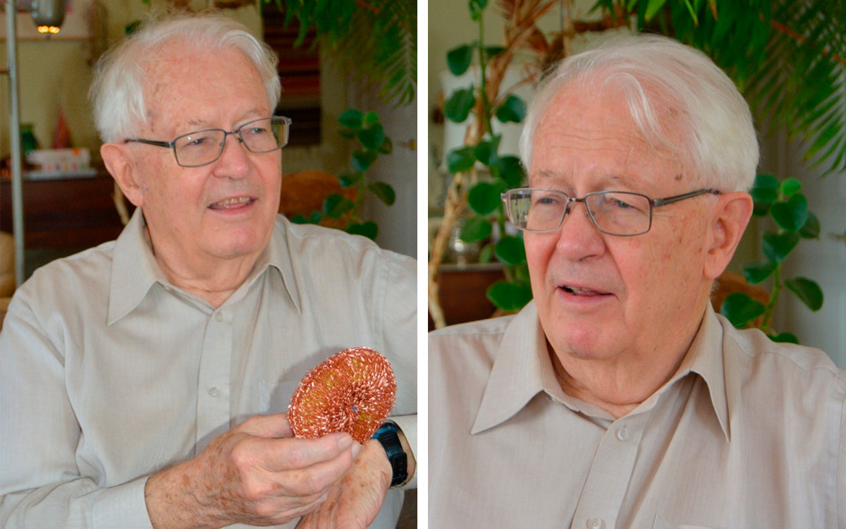
RS: This may have some very interesting properties. Semi-toroidal, conductive network shell. The Gordon West copper squeegee model!
GW: An ore is considered massive when the metallic mineral content is more than volume 30%, but sulfide ores are almost never completely massive. I don't think this sponge will show an interesting DC response, but its inductance response could be interesting. Channelizing current in narrow conductors does make a difference to electromagnetic induction, because every little piece in there has more inductance than a uniform conductor. Fine structure matters.
It's the same in magnetism too. Students get a quick education in potential field interpretation and are given a table of the typical magnetic susceptibilities of rocks. That's fine, but it’s all averages. Their takeaway is that mafic rocks have high susceptibilities, and acidic (silicic) and sedimentary rocks do not. You see almost the opposite in the real world. There are beautiful examples in Australia of rocks not displaying the magnetic susceptibilities predicted by the tables, such as magnetic iron-rich gravels that collect in the stream beds of arid terrains where deep weathering has occurred. On the Canadian Shield, most mafic rocks are significantly altered, with magnetite being one of the first things to break down. Often, the lowest susceptibility ones are the so-called greenstones. They are mafic metavolcanic rocks, and largely non-magnetic. The ironstones are highly magnetic, and there are often other noticeably magnetic sediments and granitoid intrusives. I fear there is far too much generalization and teaching to standard cases. Young people are very susceptible to that. "I was told by my professor that this is the way it is." There is the risk of freezing their thinking.
RS: I believe that exploration geophysics is actually in an existential state of crisis right now, probably the whole resource sector. We consume vast amounts of resources like oil, metals and potash. But there is enormous pressure not to do that. The question is, where can exploration geophysics go, continue to add value, and be relevant?
GW: We're looking at it from the point of view of a highly developed country. This is not what you hear in less developed parts of the world. Demand is not going away, they are very anxious, and see great value in geophysics.
RS: What do we do with exploration geophysics programs like the one at U of T?
GW: I don’t know if it is essential to have an applied geophysics program centred at U of T anymore, but we certainly need it somewhere in the province. The Ontario government mainly supports Earth Science expansion these days only if it’s based in Sudbury. The political reasons for that are quite cogent. People up north are looking for professional employment, they don't have the same access to universities as down here, and the government needs to inject money into the economy up there.
RS: So, you take the profession to where there's a requirement for it?
GW: That makes a certain amount of sense, but there’s another factor which we discussed earlier, which is many people’s urban preference. Saying you're going to create a research centre in Sudbury doesn't necessarily work, because many good people may not be willing to move there.
In my view, Ontario needs a multi-point geophysical centre and we need to stress cooperation between groups. I feel Canadian academic geophysics lost its way when we reached the point where surveys required professional equipment and scale. We didn't focus on collective action – we stuck with grants going to individual profs. I feel that to do meaningful academic field geophysics these days, we need to pool field equipment and technical expertise. The US has done this for its big seismic projects, but we haven’t done anything like that at all.
RS: The complexities you’ve mentioned, such as people’s living preferences, the resources found in cities versus those in the field, and the need for collaborations and instrument pools are indeed challenging, but critical. At the SEG, we’re trying to put offices in attractive places to live which are close to the resources and geophysical activity.
JL: Let’s shift gears. Gordon, what do you think are your highlight contributions?
GW: Well, they're all over the map. Probably my real contribution is keeping an applied geophysics program going at U of T for many years.
RS: That is huge. It certainly started my career and that of many others!
GW: A lot of students went through that program, and many got advanced degrees...probably 30 or 40 individuals directly under my supervision, and I think about 75 theses in all. I'm very proud of the fact that we kept applied geophysics going while there was also what you might call scientific geophysics, full earth geophysics, at the same time. Students could get a look at both sides.
On a more specific level, I’m proud of the work I did with Yves Lamontagne in EM - we won a Best Paper award at the SEG for that: “A time-domain electromagnetic system measuring the step-response of the ground”, was the title. We also did some pioneering work together in EM interpretation. While the ideas had all been there in the math for decades, we managed to show how, in practice, the complicated response from a good conductor in a larger but moderately conductive background can be sorted out using wideband observational data.
I'm also proud of the year I did with Thellier in France. When I came back to U of T, there were students interested in paleo- and rock magnetism. It’s a subject which is almost considered out-of-date now, which is ridiculous. We created a paleomagnetic lab at Erindale College. Henry Halls and a number of notable people went through there including Dave Symons, who went to St. FX and Windsor, and Joe Hodych who went on to Memorial in St. John’s. Also, it set up Dave Dunlop’s Ph.D. and career as a guru of rock magnetism.
RS: ...and the lunar program, which was a big feather in Canada's cap.
GW: Yes, also the lunar program with Dave Strangway, although his was a separate facility. We kept the Erindale lab going for decades, and it's done some really interesting work.
In regional geophysics, many things arose from the Lake Superior Experiments that were fantastically interesting. We carried out smaller scale refraction surveys throughout the basin over two summers, using home-built sonobuoys. That culminated in Henry Halls' Ph.D. thesis and gave us a good idea of the Keweenawan volcano-sedimentary basin structure, before the commercial seismic reflection survey took place. We went right down the axis of the Keweenawan syncline, and found this huge sort of hole in the crust. The results also hooked into some great paleomagnetism, because the volcanics there are young and not all metamorphosed to hell, so they retain a good original remanence.
RS: As an undergrad working with you in Northern Ontario, I remember being deeply impressed and inspired by your energy and happy persistence! … Gordon outworked all of us, who were much his junior. It would be 10 o'clock at night and Gordon would still be working.
GW: That was because some of my instrument design wasn't as good as it could be!
RS: But you were fixing it. You didn't say no, you didn't say this is broken, it's a failure. You worked until you fixed it.
GW: I really enjoyed working with young people, with graduate students, although I got quite fussy with the wording of their theses sometimes. I really wanted them to finish their work as a complete project, so they had something substantial to put forward. I saw my role as a professor as providing a complete environment where a person doing graduate level research could do something significant, useful and meaningful. But by the 1990s I didn’t personally want to get into anymore big projects. I still don't...well, can't. As I like to say, my salary retired in 1998!
(Laughter)
JL: Rob, I want to thank you for being so accommodating and taking part of your Christmas vacation and birthday to do this. Gordon, thank you so much, and Katri as well, for hosting and sharing your time with us. It's incredible. 40 years on the job, 20 years in retirement, and you're still going strong, still thinking of new projects.
OK: Yes, well said Jean. We really appreciate it, and it’s been fun.
GW: Well, what does any old man like to do?! Chat about his experiences, those wonderful old days.
References
American Radio Relay League, Inc., 1936, Radio Amateur’s Handbook
Smith, F. Langford, 1953, Radiotron Designer’s Handbook
West, G. F., Farquhar, R. M., Garland, G. D., Halls, H. C., Morley, L. W., & Russell, R. D. (2014, January 2). John Tuzo Wilson, A Man Who Moved Mountains. Canadian Journal of Earth Sciences, 51(3), pp. xvii-xxxi. Retrieved from https://doi.org/10.1139/cjes-2013-01
West, G.F., J.C. Macnae, and Y. Lamontagne (1984), A time-domain electromagnetic system measuring the step-response of the ground, Geophysics 49(7):1010.


Editors' Picks
- Science Break: Heart Attacks – “From the Archives”
Oliver Kuhn - The New Reservoir Characterization
John Pendrel - AVO Modeling in Seismic Processing and Interpretation Part 1. Fundamentals
Yongyi Li, Jonathan Downton, and Yong Xu - Improved AVO fluid detection and lithology discrimination using Lamé petrophysical parameters: "λp", "µp", and "λ/µ fluid stack": from P and S inversions
Bill Goodway, T. Chen and J. Downton - The wedge model revisited
Joanna Cooper, Don Lawton and Gary Margrave - Seismic Attributes – a promising aid for geologic prediction
Satinder Chopra and Kurt Marfurt - Scanning Calgary's Water Towers: Applications of Hydrogeophysics in Challenging Mountain Terrain
Craig Christensen et al. - AVO analysis in the presence of NMO stretch and offset dependent tuning
Jonathan Downton


Share This Interview